
Source: Bureau of Meteorology
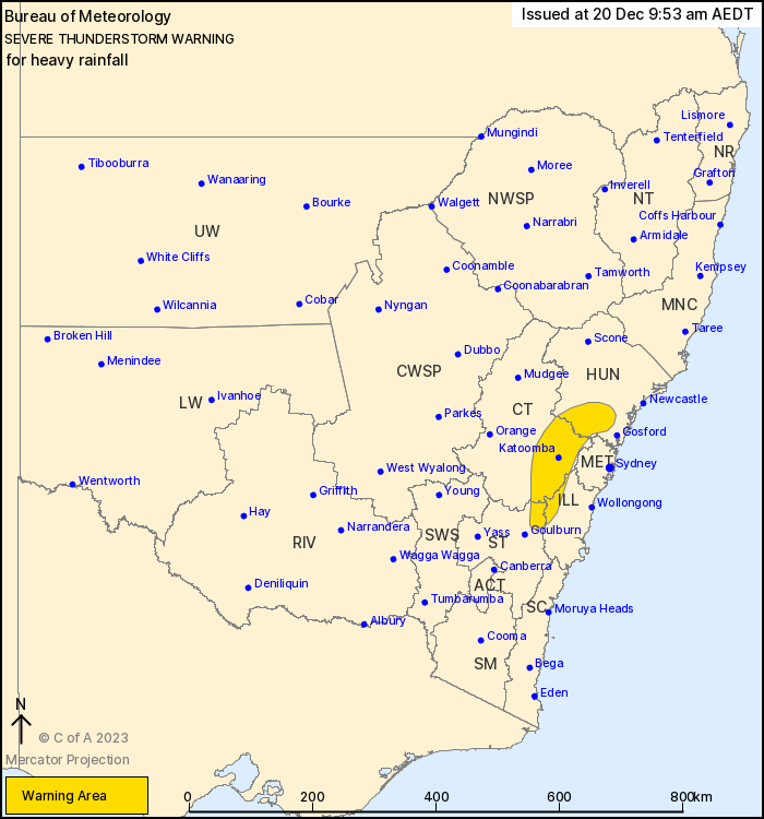
For people in parts of Hunter, Illawarra, Central Tablelands and
Southern Tablelands Forecast Districts.
Issued at 9:53 am Wednesday, 20 December 2023.
Persistent shower activity producing heavy falls about the ranges
surrounding the Sydney basin.
Weather Situation: A moist airmass ahead of a southerly change,
combined with a slow moving trough, is generating persistent shower
and possible thunderstorm activity producing heavy rainfall,
particularly in elevated parts.
Severe thunderstorms are likely to produce heavy rainfall that may
lead to flash flooding in the warning area over the next several
hours. Locations which may be affected include Katoomba, Glen
Davis, Lithgow, Jenolan Caves, Springwood and Bilpin.
45mm in the 3hrs to 09:36 am at Hampton.
58mm in the 5hrs to 09:38 am at Oberon.
The State Emergency Service advises that people should:
* Keep clear of creeks and storm drains.
* Don't walk, ride your bike or drive through flood water.
* If you are trapped by flash flooding, seek refuge in the highest
available place and ring 000 if you need rescue.
* Be aware that run-off from rainfall in fire affected areas may
behave differently and be more rapid. It may also contain debris
such as ash, soil, trees and rocks.
* After bushfires, heavy rain and the loss of foliage can make the
ground soft and heavy, leading to a greater chance of
landslides.
* Unplug computers and appliances.
* Avoid using the phone during the storm.
* Stay indoors away from windows, and keep children and pets
indoors as well.
* Stay vigilant and monitor conditions. Note that the landscape
may have changed following bushfires.
* For emergency help in floods and storms, ring the SES (NSW and
ACT) on 132 500.
19/Dec/2023 10:59 PM


