
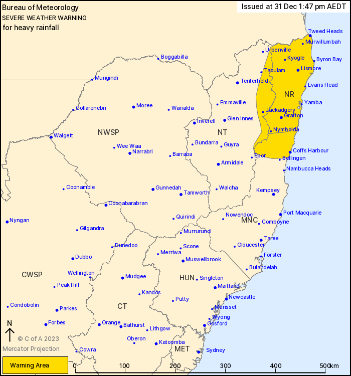
Source: Bureau of Meteorology
For people in Northern Rivers and parts of Mid North Coast and
Northern Tablelands Forecast Districts.
Issued at 1:47 pm Sunday, 31 December 2023.
Heavy rainfall about the northeast during Sunday and Monday
Weather Situation: A high pressure system moving into the Tasman
Sea is directing persistent and very humid easterly winds over
northeastern parts of New South Wales. Persistent showers and
thunderstorms with heavy rainfall are expected to trigger on a
coastal trough during Sunday and Monday, with further support from
an upper trough sitting to the southwest.
HEAVY RAINFALL which may load to FLASH FLOODING is forecast for
the Northern Rivers and parts of the Mid North Coast and Northern
Tablelands districts during Sunday and Monday. Three to six-hourly
rainfall totals between 80 and 160 mm are possible, with isolated
24-hourly totals exceeding 250 mm possible.
Heavy falls will be associated with shower and thunderstorm
activity, which is likely to be somewhat hit-and-miss in nature
across the warning area. These conditions are expected to continue
during Monday, though rainfall may ease in the Mid North Coast by
Monday morning.
Localised intense rainfall is possible under areas of persistent
heavy thunderstorms. Separate severe thunderstorm warnings may be
issued to highlight areas of intense falls if they are
detected.
A flood watch is current for parts of the warning area. Flood
warnings may be issued as required. Please refer to
http://www.bom.gov.au/nsw/warnings/
Locations which may be affected include Lismore, Grafton, Coffs
Harbour, Woolgoolga, Sawtell and Dorrigo.
110 mm recorded in Sawtell in the 2 hours to 1:15 pm.
100 mm recorded in Coffs Harbour in the 2 hours to 1:00 pm.
The State Emergency Service advises that people should:
* Don't drive, ride or walk through flood water.
* Keep clear of creeks and storm drains.
* If you are trapped by flash flooding, seek refuge in the highest
available place and ring 000 if you need rescue.
* Be aware that run-off from rainfall in fire affected areas may
behave differently and be more rapid. It may also contain debris
such as ash, soil, trees and rocks.
* After bushfires, heavy rain and the loss of foliage can make the
ground soft and heavy, leading to a greater chance of
landslides.
* Stay vigilant and monitor conditions. Note that the landscape
may have changed following bushfires.
* For emergency help in floods and storms, ring your local SES
Unit on 132 500.
31/Dec/2023 03:47 AM


