
Source: Bureau of Meteorology
Issued at 4:15 am ACST [4:45 am AEST] on Monday 18 March
2024
Headline:
Megan impacting the southwestern Gulf of Carpentaria coast and to
make landfall during today
Areas Affected:
Warning Zone
Alyangula (Groote Eylandt) in the NT to Mornington Island in Qld
(not including Mornington Island), extending inland to Borroloola,
McArthur River Mine, and Robinson River, but not including
Ngukurr.
Watch Zone
None.
Cancelled Zone
None.
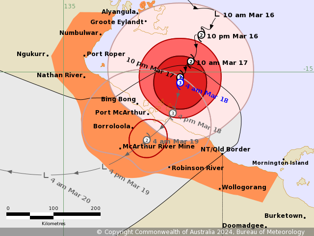
Details of Severe Tropical Cyclone Megan at 3:30 am ACST [4:00 am
AEST]:
Intensity: Category 3, sustained winds near the centre of 130
kilometres per hour with wind gusts to 185 kilometres per
hour.
Location: within 30 kilometres of 15.2 degrees South 137.2 degrees
East, estimated to be 170 kilometres south southeast of Alyangula
and 135 kilometres northeast of Borroloola.
Movement: slow moving.
Severe Tropical Cyclone Megan is moving slowly towards the south
southwest and is expected to cross the southwestern Gulf of
Carpentaria coast between about Nathan River and the Northern
Territory/Queensland border later today.
Once over land, Megan will weaken and track west through the
Northern Territory as a tropical low.
Hazards:
The VERY DESTRUCTIVE CORE of Megan, with wind gusts up to 200
km/h, will start to impact the coast between Bing Bong in the NT
and the NT/Qld border in the next few hours and will continue
throughout the day as the system slowly crosses the coast.
DESTRUCTIVE WIND GUSTS in excess of 125 km/h are occurring about
the Sir Edward Pellew Group and will extend to the southwestern
Gulf of Carpentaria coast, between Nathan River in the NT and the
NT/Qld border during today.
Gales with DAMAGING WIND GUSTS to 120 km/h will develop along the
southwestern Gulf of Carpentaria coast between Nathan River and the
NT/Qld border this morning before extending to inland areas
including Borroloola, McArthur River Mine, and Robinson River
during the day.
Gales with DAMAGING WIND GUSTS to 110 km/h are occurring over
parts of Groote Eylandt, these are expected to begin to ease during
this morning as Megan moves further away. These winds may extend
further northwest to Numbulwar in the NT, or east to Mornington
Island in Qld (not including Mornington Island), during
today.
HEAVY to locally INTENSE RAINFALL is likely about the southwestern
Gulf of Carpentaria coast during today and may even occur about
parts of the Gulf Country in Queensland. HEAVY RAINFALL will extend
to adjacent inland areas in the Carpentaria forecast district as
the system crosses the coast.
Coastal residents between Nathan River and the Northern
Territory/Queensland border are specifically warned of a DANGEROUS
STORM TIDE as the cyclone centre crosses the coast. Tides are
likely to rise significantly above the normal high tide, with
DAMAGING WAVES and DANGEROUS FLOODING.
Abnormally high tides are expected over remaining parts of the
southern Gulf for the next few days, and will likely rise above the
normal high tide at times.
Recommended Action:
The Northern Territory Emergency Service advise:
For the communities in the area of the Cyclone Warning:
- Enact your household emergency plan now
- Prepare your property - secure loose items now
- Store water for future use
- Check on your neighbours, to make sure they are prepared as
well
- Prepare to take shelter
- Listen to emergency services
Emergency services in Qld advise:
People between the Queensland/ Northern Territory border and
Mornington Island, not including Mornington Island, should take
precautions and listen to the next advice.
- Information is available from your local government
- For cyclone preparedness and safety advice, visit Queensland's
Disaster Management Services website
(www.disaster.qld.gov.au)
- For emergency assistance call the Queensland State Emergency
Service (SES) on 132 500 (for assistance with storm damage, rising
flood water, fallen trees on buildings or roof damage).
Current
Tropical Cyclones
17/Mar/2024 08:50 PM


