
Source: Bureau of Meteorology
Issued at 4:29 pm ACST [4:59 pm AEST] on Wednesday 14 February
2024
Headline:
Tropical Low 07U likely to bring strong winds and heavy rainfall
to the southern Gulf of Carpentaria coast later Thursday and
Friday.
Areas Affected:
Warning Zone
None.
Watch Zone
Port Roper (NT) to Burketown (Qld), including Mornington Island
and Borroloola, but not including Ngukurr.
Cancelled Zone
None.
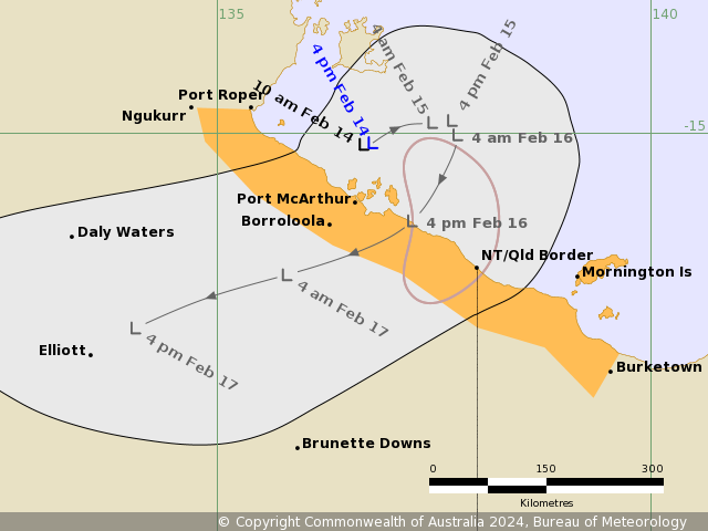
Details of Tropical Low at 3:30 pm ACST [4:00 pm AEST]:
Intensity: Tropical Low, sustained winds near the centre of 35
kilometres per hour with wind gusts to 85 kilometres per
hour.
Location: within 75 kilometres of 15.1 degrees South 136.8 degrees
East, estimated to be 120 kilometres north northeast of Borroloola
and 305 kilometres northwest of Mornington Is.
Movement: slow moving.
Tropical Low 07U is moving slowly in the Gulf of Carpentaria.
There is a moderate chance it strengthens into a tropical cyclone
overnight Thursday or during Friday. On Friday it is expected to
move southwest taking it over the southern Gulf of Carpentaria
coast and then weaken overland. On the weekend it will be moving
west over the Northern Territory.
Hazards:
GALES with DAMAGING GUSTS to 100 kilometres per hour could develop
along the coast between Port McArthur and Mornington Island early
Friday morning. Damaging gusts could extend west to Port Roper in
the Northern Territory and east to Burketown in Queensland during
Friday depending on the movement of 07U.
Periods of heavy rainfall could develop along the southern Gulf of
Carpentaria coast during Thursday, becoming more likely on Friday
as 07U moves closer to the coast.
Recommended Action:
For people in the Northern Territory NTES advises:
- People in Borroloola and surrounding areas should consider what
action they will take should the cyclone threat increase.
- Check your household plan.
- Listen for the next advice.
For cyclone safety and preparation advice
www.securent.nt.gov.au
Ensure family, friends and neighbours have received and understood
this message.
For people in Queensland between the QLD/NT border and Burketown
should consider what action they will need to take if the cyclone
threat increases.
- Information is available from your local government
- For cyclone preparedness and safety advice, visit Queensland's
Disaster Management Services website
(www.disaster.qld.gov.au)
- For emergency assistance call the Queensland State Emergency
Service (SES) on 132 500 (for assistance with storm damage, rising
flood water, fallen trees on buildings or roof damage).
Current
Tropical Cyclones
14/Feb/2024 07:20 AM


