
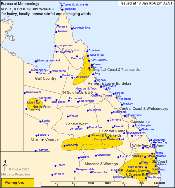
Source: Bureau of Meteorology
For people in North Tropical Coast and Tablelands, Darling Downs
and Granite Belt, Southeast Coast and parts of Northern Goldfields
and Upper Flinders, Herbert and Lower Burdekin, North West, Central
Highlands and Coalfields, Central West, Channel Country, Wide Bay
and Burnett, Maranoa and Warrego and Peninsula Forecast
Districts.
Issued at 6:56 pm Thursday, 18 January 2024.
Severe thunderstorms across the south and southeast as well as
over the tropical north.
Weather situation: A trough is moving over southern Queensland
with a very moist tropical airmass in place. Severe thunderstorms
have formed this afternoon and should continue to develop and
spread further east throughout the evening. Another trough is
producing slow-moving severe storms across the wet tropics.
VERY DANGEROUS THUNDERSTORMS are likely to produce heavy, locally
intense rainfall that may lead to dangerous and life-threatening
flash flooding over the next several hours in parts of the North
Tropical Coast and Tablelands district. Locations which may be
affected include Mareeba, Mossman and Julatten.
Severe thunderstorms are likely to produce heavy rainfall that may
lead to flash flooding over the next several hours in the North
Tropical Coast and Tablelands and parts of the Northern Goldfields
and Upper Flinders, Herbert and Lower Burdekin, North West, Central
Highlands and Coalfields, Central West, Channel Country, Maranoa
and Warrego and Peninsula districts. Locations which may be
affected include Mount Isa, Cairns, Port Douglas, Windorah, and
Redlynch.
Severe thunderstorms are likely to produce heavy rainfall that may
lead to flash flooding and damaging winds over the next several
hours in the Darling Downs and Granite Belt, Southeast Coast and
parts of the Wide Bay and Burnett and Maranoa and Warrego
districts. Locations which may be affected include Warwick, Gold
Coast, Toowoomba, Brisbane, Dalby, Maroochydore, Gympie, Kingaroy,
Stanthorpe, Goondiwindi, Coolangatta and Ipswich.
Significant observations:
52mm in the 1hr to 5:27pm at Dalby
42mm in the 30mins to 5:00pm at Goombungee
50mm in the 30mins to 4:24pm at Barongarook
Emergency services advise people to:
* If you have children make sure they are with you or an adult you
trust.
* Park your car undercover away from trees.
* Close doors and windows.
* Keep asthma medications close by. Storms and wind can trigger
asthma attacks.
* Charge mobile phones and power banks in case the power goes
out.
* Put your pets somewhere safe and make sure they can be
identified in case they get lost.
* Do not drive now unless you have to because conditions are
dangerous.
* Tell friends, family and neighbours in the area.
* Go inside a strong building now. Stay inside until the storm has
passed.
18/Jan/2024 09:03 AM


