
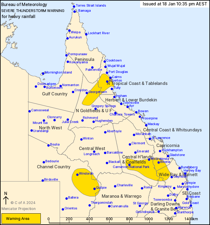
Source: Bureau of Meteorology
For people in parts of North Tropical Coast and Tablelands,
Northern Goldfields and Upper Flinders, Central Highlands and
Coalfields, Channel Country, Capricornia, Wide Bay and Burnett,
Darling Downs and Granite Belt, Peninsula, Herbert and Lower
Burdekin, Central West and Maranoa and Warrego Forecast
Districts.
Issued at 10:35 pm Thursday, 18 January 2024.
Severe thunderstorms ongoing in southern parts as well as the
tropical north.
Weather situation: A trough is moving over southern Queensland
with a very moist tropical airmass in place. Severe thunderstorms
are ongoing in parts of the south and across the wet tropics.
Severe thunderstorms are likely to produce heavy rainfall that may
lead to flash flooding in the warning area over the next several
hours. Locations which may be affected include Quilpie, Windorah,
Biloela, Innisfail, Mareeba and Julatten.
Significant observations:
59 mm in the 1hr to 8:26 pm at Beaudesert
70 mm in the 2hrs to 7:39 pm at Mt Sugarloaf
77 mm in the 2hrs to 7:16 pm at Mount Isa Airport
Emergency services advise people to:
* Park your car undercover away from trees.
* Close doors and windows.
* Keep asthma medications close by. Storms and wind can trigger
asthma attacks.
* Charge mobile phones and power banks in case the power goes
out.
* Put your pets somewhere safe and make sure they can be
identified in case they get lost.
* Do not drive now unless you have to because conditions are
dangerous.
* Tell friends, family and neighbours in the area.
* Go inside a strong building now. Stay inside until the storm has
passed.
18/Jan/2024 12:41 PM


