
Source: Bureau of Meteorology
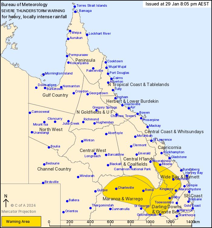
For people in parts of Central Highlands and Coalfields,
Capricornia, Wide Bay and Burnett, Maranoa and Warrego and Darling
Downs and Granite Belt Forecast Districts.
Issued at 8:05 pm Monday, 29 January 2024.
AREA OF LIKELY INTENSE RAINFALL EXTENDING FROM KILKIVAN INTO THE
CENTRAL DARLING DOWNS.
Weather Situation: A low pressure trough and a very humid,
unstable air mass lie over the southern interior of Queensland,
triggering thunderstorms with heavy to intense rainfall.
Severe thunderstorms are likely to produce heavy rainfall that may
lead to flash flooding over the next several hours in parts of the
Central Highlands and Coalfields, Capricornia, Wide Bay and
Burnett, Maranoa and Warrego and Darling Downs and Granite Belt
districts. Locations which may be affected include Roma,
Charleville, and Goondiwindi.
VERY DANGEROUS THUNDERSTORMS are likely to produce heavy, locally
intense rainfall that may lead to dangerous and life-threatening
flash flooding and damaging winds over the next several hours in
parts of the Wide Bay and Burnett and Darling Downs and Granite
Belt districts. Locations likely to be affected include Tara,
Kingaroy, and Kilkivan.
57 mm in 1 hour to 5:07 am at Consuelo Alert (southern Central
Highlands)
53 mm in 1 hour to 6:43 am at Wallumbilla TM (east of Roma)
105 mm in 3 hours to 5:14 pm at St George.
102 km/h wind gust at St George at 2:47 pm.
Emergency services advise people to:
* If you have children make sure they are with you or an adult you
trust.
* Park your car undercover away from trees.
* Close doors and windows.
* Keep asthma medications close by. Storms and wind can trigger
asthma attacks.
* Charge mobile phones and power banks in case the power goes
out.
* Put your pets somewhere safe and make sure they can be
identified in case they get lost.
* Do not drive now unless you have to because conditions are
dangerous.
* Tell friends, family and neighbours in the area.
* Go inside a strong building now. Stay inside until the storm has
passed.
29/Jan/2024 10:12 AM


