
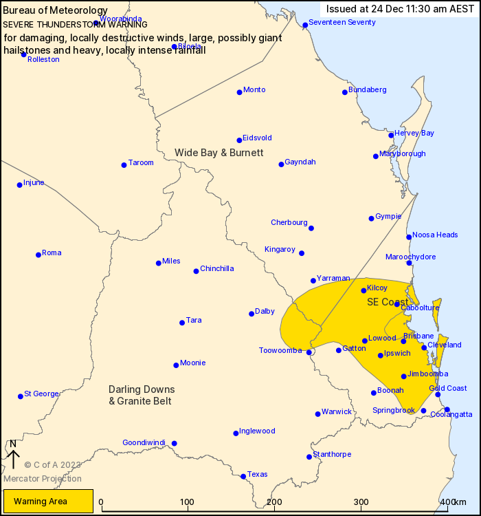
Source: Bureau of Meteorology
For people in parts of Wide Bay and Burnett, Darling Downs and
Granite Belt and Southeast Coast Forecast Districts.
Issued at 11:30 am Sunday, 24 December 2023.
Severe thunderstorms are moving across southeast Queensland.
Weather Situation: An upper trough is moving over southeast
Queensland and is causing thunderstorm activity in a moist and
unstable airmass.
Severe thunderstorms are likely to produce damaging winds, large
hailstones and heavy rainfall that may lead to flash flooding over
the next several hours in parts of the Wide Bay and Burnett,
Darling Downs and Granite Belt and Southeast Coast districts.
Locations which may be affected include Brisbane, Caboolture,
Ipswich, Jimboomba, Mount Tamborine and Redcliffe.
Severe thunderstorms are likely to produce damaging, locally
destructive winds, large, possibly giant hailstones and heavy,
locally intense rainfall that may lead to dangerous and
life-threatening flash flooding over the next several hours in
parts of the Southeast Coast district. Locations which may be
affected include Moreton Island and Redcliffe.
40mm was recorded at Gatton in 30min to 11:00am
35mm was recorded at Sandy Creek Road in 30min to 10:45am
30mm was recorded at Gambubal in 30min to 10:30am
Emergency services advise people to:
* If you have children make sure they are with you or an adult you
trust.
* Pack away, secure or tie down outdoor furniture, toys and
trampolines if it s safe to do so.
* Stay away from windows if there is giant hail.
* Park your car undercover away from trees.
* Close doors and windows.
* Keep asthma medications close by. Storms and wind can trigger
asthma attacks.
* Charge mobile phones and power banks in case the power goes
out.
* Put your pets somewhere safe and make sure they can be
identified in case they get lost.
* Do not drive now unless you have to because conditions are
dangerous.
* Tell friends, family and neighbours in the area.
24/Dec/2023 01:36 AM


