
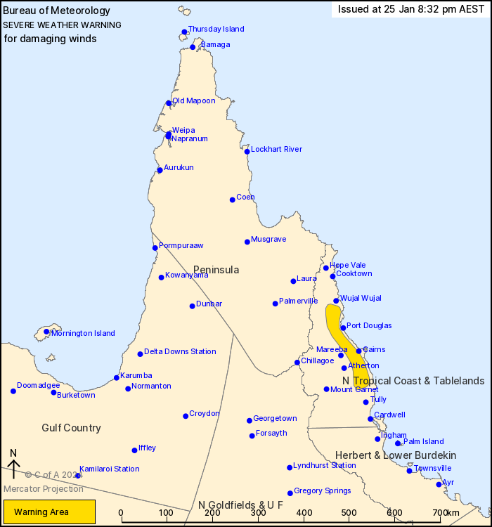
Source: Bureau of Meteorology
For people in parts of North Tropical Coast and Tablelands
Forecast District.
Issued at 8:32 pm Thursday, 25 January 2024.
Localised damaging wind gusts likely tonight in the North Tropical
Coast.
Weather Situation: Severe Tropical Cyclone Kirrily is making
landfall in the Herbert and Lower Burdekin near Townsville. Strong
westerly winds on the north side of the system are resulting in
damaging wind gusts across the North Tropical Coast.
DAMAGING WIND GUSTS with peak gusts of around 100 km/h are likely
about elevated terrain and valleys in the North Tropical Coast
tonight.
Winds are expected to ease during Friday morning and Tropical
Cyclone Kirrily weakens and moves inland.
A Severe Weather Warning for HEAVY, LOCALLY INTENSE RAINFALL AND
DAMAGING WINDS is also current for inland parts of Queensland. See
http://www.bom.gov.au/qld/warnings/ for details.
A separate Tropical Cyclone Advice is current for areas closer to
the coast. See http://www.bom.gov.au/cyclone/index.shtml for more
information.
A Flood Watch is also current for coastal and adjacent inland
catchments between Tully and Airlie Beach, and parts of the Central
West and Gulf catchments. See http://www.bom.gov.au/qld/warnings/
for more information.
Locations which may be affected include Mossman, Gordonvale,
Daintree Village, Babinda, Julatten and Redlynch.
Emergency services advise people to:
* Park your car undercover away from trees.
* Close doors and windows.
* Keep asthma medications close by. Storms and wind can trigger
asthma attacks.
* Charge mobile phones and power banks in case the power goes
out.
* Put your pets somewhere safe and make sure they can be
identified in case they get lost.
* Do not drive now unless you have to because conditions are
dangerous.
* Tell friends, family and neighbours in the area.
* Go inside a strong building now. Stay inside until the storm has
passed.
25/Jan/2024 10:38 AM


