
Source: Bureau of Meteorology
For people in parts of North West, Central West, Channel Country
and Northern Goldfields and Upper Flinders Forecast
Districts.
Issued at 11:01 am Monday, 29 January 2024.
Ex-Tropical Cyclone Kirrily continues to produce heavy rainfall
across the western interior of Queensland.
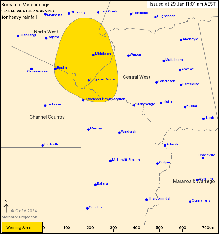
Weather Situation: Ex-Tropical Cyclone Kirrily is currently
located east of Middleton. It is forecast to remain slow-moving
across the western interior today and through to Wednesday. Looking
ahead, the system is expected to meander across the interior of the
state, although there is vast uncertainty as to its future track
and intensity.
HEAVY RAINFALL which may lead to FLASH FLOODING is forecast for
the southeastern North West, western Central West, northern Channel
Country and far southwestern Northern Goldfields & Upper
Flinders districts. 6-hourly rainfall totals between 60 to 90 mm
are likely to continue, with isolated falls up to 110 mm possible.
24-hourly rainfall totals of 90 to 140 mm are also likely to
continue, with isolated falls up to 200 mm.
A Flood Watch and several Flood Warnings are also current for the
Central West, Channel Country and Gulf of Carpentaria catchments.
See http://www.bom.gov.au/qld/warnings/ for more information.
Locations which may be affected include Boulia, Selwyn, Mckinlay,
Brighton Downs and Middleton.
Significant rainfall observations from 9am Sunday to 9am Monday
AEST:
256 mm at Seymour Gap
244 mm at Kirby
154 mm at McKinlay.
Emergency services advise people to:
* Park your car undercover away from trees.
* Close doors and windows.
* Keep asthma medications close by. Storms and wind can trigger
asthma attacks.
* Charge mobile phones and power banks in case the power goes
out.
* Put your pets somewhere safe and make sure they can be
identified in case they get lost.
* Do not drive now unless you have to because conditions are
dangerous.
* Tell friends, family and neighbours in the area.
* Go inside a strong building now. Stay inside until the storm has
passed.
29/Jan/2024 01:14 AM


