
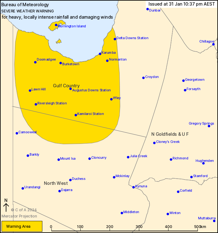
Source: Bureau of Meteorology
For people in parts of Gulf Country and North West Forecast
Districts.
Issued at 10:37 pm Wednesday, 31 January 2024.
HEAVY TO LOCALLY INTENSE RAINFALL AND DAMAGING WINDS IN THE
NORTHWEST AROUND EX-TROPICAL CYCLONE KIRRILY
Weather situation: Ex-Tropical Cyclone Kirrily is currently
located about 175 km to the north of Mount Isa. The system is
expected to continue tracking steadily to the north-northwest
tonight and into Thursday morning. It is then expected to stall
very close to the Gulf Country coast on Thursday afternoon, where
it will likely linger until it starts to move southwards from
Friday night.
HEAVY RAINFALL which may lead to FLASH FLOODING is ongoing in
northern parts of the North West district, and is expected to
extend into the Gulf Country overnight. Six-hourly rainfall totals
between 90 and 150 mm are likely. 24-hourly totals between 100 and
200 mm are also possible.
Locally INTENSE RAINFALL which may lead to DANGEROUS AND
LIFE-THREATENING FLASH FLOODING is also possible on the southern
and eastern flanks of the system from Thursday morning, though
becoming more likely from Thursday afternoon. Isolated six-hourly
totals between 150 and 200 mm are possible, with 24-hourly totals
between 200 and 300 mm possible. A separate Severe Thunderstorm
Warning will be issued if VERY DANGEROUS THUNDERSTORMS with INTENSE
RAINFALL are detected.
DAMAGING WIND GUSTS in excess of 90 km/h are possible over
northern parts of the warning area from Thursday afternoon.
Locally DAMAGING WINDS averaging 60 to 70 km/h are possible over
the coastal fringe, including Mornington Island and other Gulf of
Carpentaria islands, from late Thursday afternoon and
evening.
A Flood Watch and several Flood Warnings are also current for the
Central West, Channel Country and Gulf of Carpentaria catchments.
See http://www.bom.gov.au/qld/warnings/ for more information.
Locations which may be affected include Mornington Island,
Normanton, Doomadgee, Burketown, Karumba and Augustus Downs
Station.
147 mm recorded at Trepell Airport in the 24 hours to 9am
Thursday.
83 mm recorded at Dugald River since 9am Thursday.
Emergency services advise people to:
* If you have children make sure they are with you or an adult you
trust.
* Park your car undercover away from trees.
* Close doors and windows.
* Keep asthma medications close by. Storms and wind can trigger
asthma attacks.
* Charge mobile phones and power banks in case the power goes
out.
* Put your pets somewhere safe and make sure they can be
identified in case they get lost.
* Do not drive now unless you have to because conditions are
dangerous.
* Tell friends, family and neighbours in the area.
* Go inside a strong building now. Stay inside until the storm has
passed.
31/Jan/2024 04:15 PM


