
Source: Bureau of Meteorology
For people in parts of Ipswich, Logan, Somerset, Scenic Rim, South
Burnett, Gold Coast, Brisbane City, Moreton Bay and Toowoomba
Council Areas.
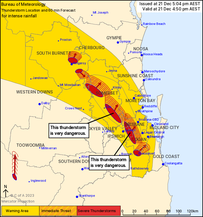
Issued at 5:04 pm Thursday, 21 December 2023.
INTENSE RAINFALL IN SLOW MOVING THUNDERSTORMS BETWEEN IPSWICH AND
BRISBANE
The Bureau of Meteorology warns that, at 4:50 pm, VERY DANGEROUS
THUNDERSTORMS likely to produce heavy, locally intense rainfall
that may lead to dangerous and life-threatening flash flooding were
detected near southern Lake Wivenhoe, northern Lake Wivenhoe and
Redbank Plains. These thunderstorms are moving towards the
northeast. They are forecast to affect Wacol, Upper Brookfield and
Mount Nebo by 5:20 pm and Samford, the D'Aguilar Ranges and
Somerset Dam by 5:50 pm.
Other severe thunderstorms were detected near Beaudesert, Nanango
and Blackbutt. They are forecast to affect Moore, Linville and the
area north of Kingaroy by 5:20 pm and the area west of Kilcoy and
Tamborine by 5:50 pm.
Emergency services advise people to:
* If you have children make sure they are with you or an adult you
trust.
* Park your car undercover away from trees.
* Close doors and windows.
* Keep asthma medications close by. Storms and wind can trigger
asthma attacks.
* Charge mobile phones and power banks in case the power goes
out.
* Put your pets somewhere safe and make sure they can be
identified in case they get lost.
* Do not drive now unless you have to because conditions are
dangerous.
* Tell friends, family and neighbours in the area.
* Go inside a strong building now. Stay inside until the storm has
passed.
21/Dec/2023 07:29 AM

