
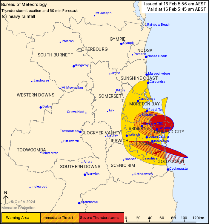
Source: Bureau of Meteorology
For people in Redland City and parts of Ipswich, Logan, Gold
Coast, Brisbane City, Moreton Bay and Scenic Rim Council
Areas.
Issued at 5:56 am Friday, 16 February 2024.
Heavy falls likely with persistent showers in southeast
Queensland.
The Bureau of Meteorology warns that, at 5:45 am, severe
thunderstorms likely to produce heavy rainfall that may lead to
flash flooding were detected near Cleveland, Mud Island and Jacobs
Well. They are forecast to affect Nudgee, Boondall and Sandgate by
6:15 am and Brisbane CBD, Strathpine and Brighton by 6:45 am.
63 mm recorded in an hour at Parklands north of Beenleigh at 1:30
am
84mm was recorded at Brisbane in 2 hrs at 2:30am
85mm was recorded at Brisbane City in 2 hrs at 2:45am
83mm was recorded at Rosalie in 2 hrs at 2:30am, 98 mm in 3
hrs.
88mm was recorded in Toowong in 2 hrs at 2:45am
90mm was recorded in Green hills in 2 hrs at 2:45am
80mm was recorded in Mt Coot-Tha in 2 hrs at 2:45am
Emergency services advise people to:
* Park your car undercover away from trees.
* Close doors and windows.
* Keep asthma medications close by. Storms and wind can trigger
asthma attacks.
* Charge mobile phones and power banks in case the power goes
out.
* Put your pets somewhere safe and make sure they can be
identified in case they get lost.
* Do not drive now unless you have to because conditions are
dangerous.
* Tell friends, family and neighbours in the area.
* Go inside a strong building now. Stay inside until the storm has
passed.
15/Feb/2024 08:04 PM


