
Source: Bureau of Meteorology
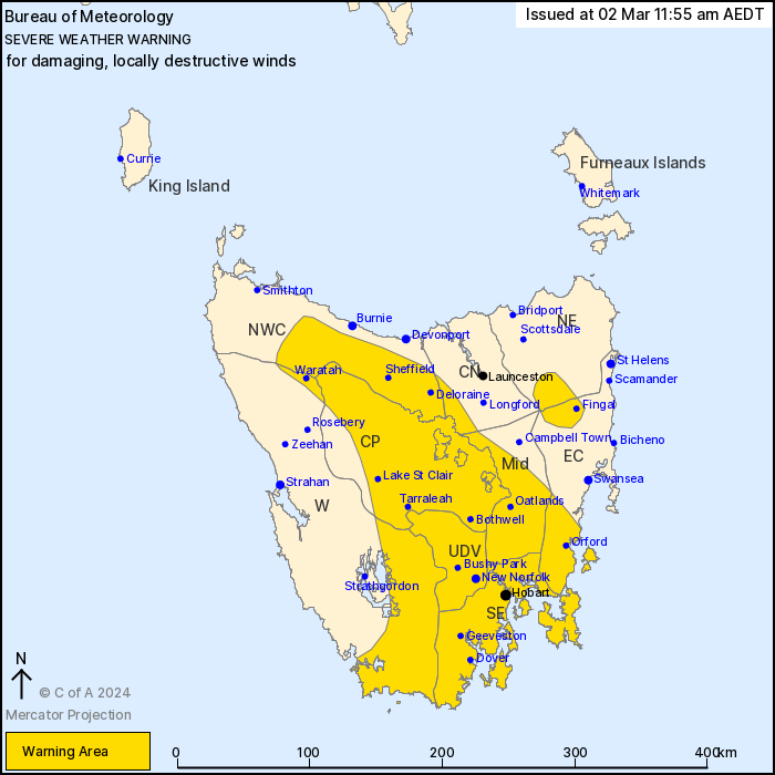
For people in Upper Derwent Valley, South East, Central Plateau,
Midlands and parts of Western, North East, East Coast, North West
Coast and Central North Forecast Districts.
Issued at 11:55 am Saturday, 2 March 2024.
DAMAGING TO LOCALLY DESTRUCTIVE WINDS ARE EXPECTED ON
SUNDAY.
Weather Situation: A vigorous cold front will cross Tasmania
during Sunday morning. Strong west to southwesterly winds are
expected around the front and will continue into Sunday afternoon
as an increased southwesterly pressure gradient remains in its
wake.
Strong to DAMAGING WINDS of 55 to 65 km/h with peak gusts up to
110 km/h are likely over parts of Tasmania from before sunrise on
Sunday morning, particularly over elevated terrain through the
centre of the state and also exposed areas in the south and
southeast coastline. This includes the Hobart area.
Locally DESTRUCTIVE WIND GUSTS in excess of 125 km/h are possible
over Western Tiers and its immediate adjacent slopes after sunrise
and could continue until early afternoon on Sunday.
Winds are expected to drop below warning thresholds during the
early afternoon, but may continue about the Western Tiers and the
immediate adjacent slopes until mid-afternoon on Sunday.
Locations which may be affected include Deloraine, Sheffield,
Oatlands, Orford, Fingal, New Norfolk, Bothwell, Tarraleah, Hobart,
Geeveston, Dover, Huonville and Dodges Ferry.
The State Emergency Service advises that people should:
* Supervise children closely.
* Check that family and neighbours are aware of warnings.
* Manage pets and livestock.
* Secure outdoor items including furniture and play
equipment.
* Be prepared in case of power outages and report any outages to
TasNetworks on 132 004.
* Beware of damaged trees and power lines and take care when
driving.
* Listen to the ABC radio or check www.ses.tas.gov.au for further
advice.
* For emergency assistance contact the SES on 132500.
02/Mar/2024 01:10 AM


