
Source: Bureau of Meteorology
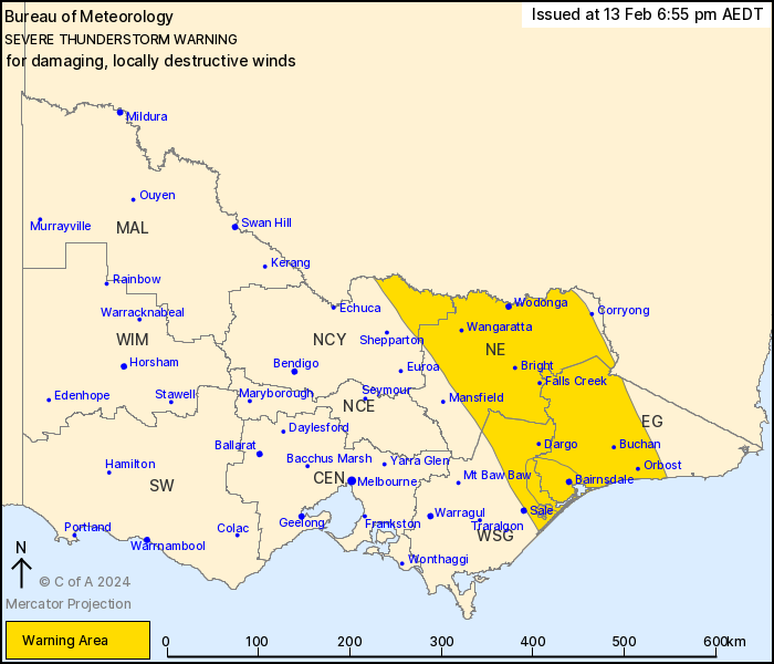
For people in East Gippsland, North East and parts of Northern
Country and West and South Gippsland Forecast Districts.
Issued at 6:55 pm Tuesday, 13 February 2024.
VERY DANGEROUS THUNDERSTORMS WITH DESTRUCTIVE WINDS POSSIBLE,
TRACKING EAST OF MAFFRA TOWARDS BAIRNSDALE.
Weather Situation: A trough will cross the state today, with gusty
severe thunderstorms likely ahead of this feature.
Severe thunderstorms are likely to produce damaging winds over the
next several hours in the East Gippsland, North East and parts of
the Northern Country and West and South Gippsland districts.
Locations which may be affected include Yarrawonga, Wodonga,
Wangaratta, Bright, Dargo, Bairnsdale, Orbost, Buchan, Falls Creek,
Mt Hotham, Mt Buller and Omeo.
VERY DANGEROUS THUNDERSTORMS are likely to produce damaging,
locally destructive winds over the next several hours in parts of
the East Gippsland and West and South Gippsland districts.
Locations which may be affected include Bairnsdale.
Severe thunderstorms are no longer occurring in the Central,
Mallee and North Central districts and the warning for these
districts is CANCELLED.
130 km/h wind gust recorded at Mt Gellibrand at 11:35 am.
126 km/h wind gust recorded at Yarram Airport at 5:06 pm.
122 km/h wind gust recorded at Avalon airport at 2:19 pm.
119 km/h wind gust recorded at Eildon Fire Tower at 5:30 pm.
117 km/h wind gust recorded at Swan Hill at 4:22 pm.
115 km/h wind gust recorded at Fawkner Beacon at 3:09 pm.
106 km/h wind gust recorded at Frankston at 3:11 pm.
102 km/h wind gust recorded at Point Wilson at 2:22 pm.
98 km/h wind gust recorded at Melbourne Airport at 3:17 pm.
96 km/h wind gust recorded at Mangalore at 4:51 pm.
98 km/h wind gust recorded at Mt William at 9:41 am.
94 km/h wind gust recorded at Falls Creek AIrport at 6:46
pm.
93 km/h wind gust recorded at Hopetoun Airport at 3:33 pm.
93 km/h wind gust recorded at Kilmore Gap at 4:13 pm.
The State Emergency Service advises that people should:
* If driving conditions are dangerous, safely pull over away from
trees, drains, low-lying areas and floodwater. Avoid travel if
possible.
* Stay safe by avoiding dangerous hazards, such as floodwater,
mud, debris, damaged roads and fallen trees.
* Be aware - heat, fire or recent storms may make trees unstable
and more likely to fall when it's windy or wet.
* Check that loose items, such as outdoor settings, umbrellas and
trampolines are safely secured. Move vehicles under cover or away
from trees.
* Stay indoors and away from windows.
* If outdoors, move to a safe place indoors. Stay away from trees,
drains, gutters, creeks and waterways.
* Stay away from fallen powerlines - always assume they are
live.
* Be aware that in fire affected areas, rainfall run-off into
waterways may contain debris such as ash, soil, trees and rocks.
Heavy rainfall may also increase the potential for landslides and
debris across roads.
* Stay informed: Monitor weather warnings, forecasts and river
levels at the Bureau of Meteorology website, and warnings through
VicEmergency website/app/hotline.
13/Feb/2024 08:02 AM


