
Source: Bureau of Meteorology
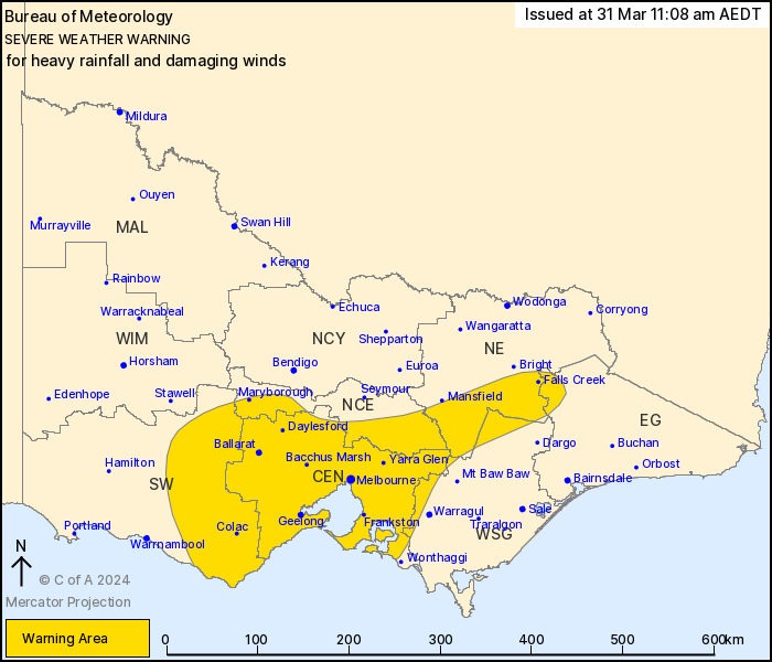
For people in Central and parts of South West, North Central,
North East, West and South Gippsland and East Gippsland Forecast
Districts.
Issued at 11:08 am Sunday, 31 March 2024.
Heavy rainfall and damaging wind gusts developing about parts of
Victoria.
Weather Situation: A strengthening cold front moving across the
southeast of the country on Monday will trigger thunderstorms
across the west of the state during the morning. These
thunderstorms will develop into a cloud band during Monday
afternoon and and shift east overnight into Tuesday morning as an
upper trough drags down moisture from northern Australia, leading
to a risk of heavy rainfall.
HEAVY RAINFALL which may lead to FLASH FLOODING is forecast for
the South West and western parts of the Central district with
thunderstorms and areas of rain during Monday afternoon, shifting
into eastern parts of the Central district overnight Monday and
into Tuesday morning. Six-hourly rainfall totals between 30 to 50
mm are likely, with isolated falls of 70 mm possible.
DAMAGING WIND GUSTS with peak gusts of around 90 km/h are possible
across the central and northeastern ranges from Monday
evening.
Heavy rainfall and damaging wind gusts are forecast to ease below
warning thresholds on Tuesday morning.
Locations which may be affected include Maryborough, Kyneton,
Ballarat, Geelong, Melbourne and Bacchus Marsh.
The State Emergency Service advises that people should:
* If driving conditions are dangerous, safely pull over away from
trees, drains, low-lying areas and floodwater. Avoid travel if
possible.
* Stay safe by avoiding dangerous hazards, such as floodwater,
mud, debris, damaged roads and fallen trees.
* Be aware - heat, fire or recent storms may make trees unstable
and more likely to fall when it's windy or wet.
* Check that loose items, such as outdoor settings, umbrellas and
trampolines are safely secured. Move vehicles under cover or away
from trees.
* Stay indoors and away from windows.
* If outdoors, move to a safe place indoors. Stay away from trees,
drains, gutters, creeks and waterways.
* Stay away from fallen powerlines - always assume they are
live.
* Be aware that in fire affected areas, rainfall run-off into
waterways may contain debris such as ash, soil, trees and rocks.
Heavy rainfall may also increase the potential for landslides and
debris across roads.
* Stay informed: Monitor weather warnings, forecasts and river
levels at the Bureau of Meteorology website, and warnings through
VicEmergency website/app/hotline.
31/Mar/2024 12:32 AM


