
Source: Bureau of Meteorology
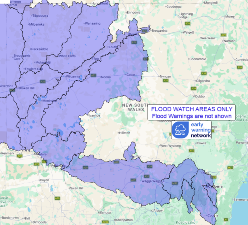
Flood Watch for parts of Far Western New South Wales and the
Murrumbidgee River Catchment
Issued at 12:53 pm AEDT on Monday 2 March 2026
Flood Watch Number: 8
FLOODING OCCURRING IN PARTS OF FAR WESTERN NEW SOUTH WALES WITH
ADDITIONAL AREAS OF FLOODING POSSIBLE IN PARTS OF THE MURRUMBIDGEE
RIVER CATCHMENT OVER THE COMING DAYS
A trough in the far west of New South Wales is slowly moving east
towards the central inland areas of the state, drawing moisture
southwards from central Australia. Widespread rainfall is forecast
to gradually extend eastwards across the Flood Watch area during
Monday and into Tuesday, with heavy to locally intense falls
likely.
Catchments are becoming wet from rainfall over the last few days
across parts of the Flood Watch area, and are expected to respond
to further rainfall.
Widespread heavy to locally intense rainfall is expected to
exacerbate isolated river and creek level rises, localised
flooding, and overland inundation which are occurring across parts
of the Flood Watch area. These conditions are likely to affect road
access in many areas in coming days. Some communities may become
isolated. Check road conditions before travelling.
At this stage, river levels along the Barwon-Darling,
Murrumbidgee, Tumut, Queanbeyan and Molonglo rivers are expected to
remain below minor flood levels, but localised flooding is
possible.
A Severe Weather Warning for heavy, locally intense, rainfall is
current for parts of the Flood Watch area.
Flood Classes (minor, moderate, major) are only defined for
catchments where the Bureau provides a flood warning service.
Catchments likely to be affected include:
Lower Murrumbidgee River(Localised)
Tumut River(Localised)
Upper Murrumbidgee River to Burrinjuck Dam and Cooma
Ck(Localised)
Murrumbidgee River to Wagga Wagga(Localised)
Queanbeyan and Molonglo Rivers(Localised)
Willandra Lakes
Paroo River (NSW)(Minor flood warning current for Paroo (NSW)
River)
Darling River(Localised)
Mount Gunderbooka to Wokabity Lake
Bynguano-Lower Barrier Ranges
Danggali Rivers and Creeks
Cooper Creek
Lake Frome
Bulla-Bancannia District
Flood warnings are current for the following catchment(s):
Paroo
For the latest flood and weather warnings see
www.bom.gov.au/weather-and-climate/warnings-and-alerts
For the latest rainfall and river level information see
www.bom.gov.au/australia/flood
Safety Advice:
Don't drive, walk, swim or play in floodwater because it is
dangerous.
Stay away from flooded drains, rivers, streams and
waterways.
Obey road closure signs. Plan ahead so you don't drive on flooded
roads.
Check the ABC and local media for updates. The situation can
change quickly, so stay informed.
For local emergency management warnings and advice visit
www.ses.nsw.gov.au.
For emergency assistance call SES on telephone number 132 500. In
life-threatening emergencies, call 000 (triple zero)
immediately.
Rainfall and River
Conditions Map
02/Mar/2026 02:16 AM

