
Source: Bureau of Meteorology
Issued at 12:34 pm EST on Thursday 22 May 2025
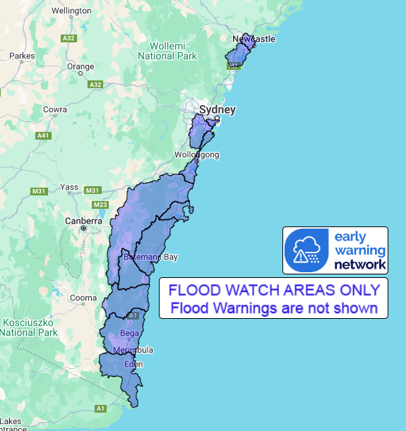
Flood Watch Number: 7
MINOR TO MAJOR FLOODING OCCURRING IN PARTS OF THE NORTHERN RIVERS,
MID NORTH COAST, HUNTER AND CENTRAL COAST CATCHMENTS
FURTHER MINOR FLOODING POSSIBLE FROM CENTRAL COAST TO SOUTH COAST
NSW
A coastal trough along the NSW coast is bringing widespread
moderate to heavy rainfall with isolated thunderstorms along
northern and central parts of the coast and ranges, mainly
affecting the Mid North Coast, Hunter and Blue Mountains regions.
This has caused minor to major flooding from the southern parts of
the Northern Rivers through to the Central Coast catchments.
Rainfall will extend further southwards during the remainder of
Thursday into Friday, extending the Flood Watch area further south.
Rainfall will ease in the northern parts of the coast from Friday,
and clear most of the state by the weekend. Minor flooding is
possible in parts of the Central and South Coast from Friday with
the movement of the trough.
Catchments in the Flood Watch area are relatively wet.
Localised river level rises, and flash flooding are possible
within the areas of heaviest rainfall.
Flood Classes (minor, moderate, major) are only defined for
catchments where the Bureau provides a flood warning service.
A Severe Weather Warning is current for Mid North Coast and parts
of Hunter, Metro, Illawarra, Central Tablelands, Northern
Tablelands and Southern Tablelands Districts.
Catchments likely to be affected include:
Newcastle Area
Lake Macquarieminor flooding
Cooks Riverminor flooding
Georges and Woronora Riversminor flooding
Illawarra Coast
Shoalhaven Riverminor flooding
St Georges Basinminor flooding
Clyde Riverminor flooding
Moruya and Deua Riversminor flooding
Tuross River
Bega Riverminor flooding
Towamba River
Minor to major flood warnings are current in the following
catchments: Northern Rivers (Orara), Mid North Coast (Coffs Coast,
Bellinger, Nambucca, Macleay, Hastings, Camden Haven, Manning and
Gloucester, Myall, Wallis Lake) Hunter and Central Coast (Hunter
and Wollombi Brook, Paterson and Williams, Tuggerah Lake), Sydney
catchments (Hawkesbury Nepean).
For the latest flood and weather warnings see
www.bom.gov.au/nsw/warnings/
For the latest rainfall and weather forecasts see
www.bom.gov.au/australia/meteye/
For the latest rainfall and river level information see
www.bom.gov.au/nsw/flood
Flood Safety Advice:
This Flood Watch means that people living or working along rivers
and streams must monitor the latest weather forecasts and warnings
and be ready to move to higher ground should flooding
develop.
Flood Warnings will be issued if Minor Flood Level is expected to
be exceeded at key sites along the main rivers for which the Bureau
of Meteorology provides a flood warning service.
Severe Weather Warnings will be issued or updated if very heavy
rain is forecast or observed.
For more information on the Flood Watch Service:
http://www.bom.gov.au/water/floods/floodWarningServices.shtml
FloodSafe advice is available at www.ses.nsw.gov.au
For emergency assistance call the SES on telephone number 132
500
For life threatening emergencies, call 000 immediately
Rainfall and River
Conditions Map
22/May/2025 02:50 AM


