
Source: Bureau of Meteorology
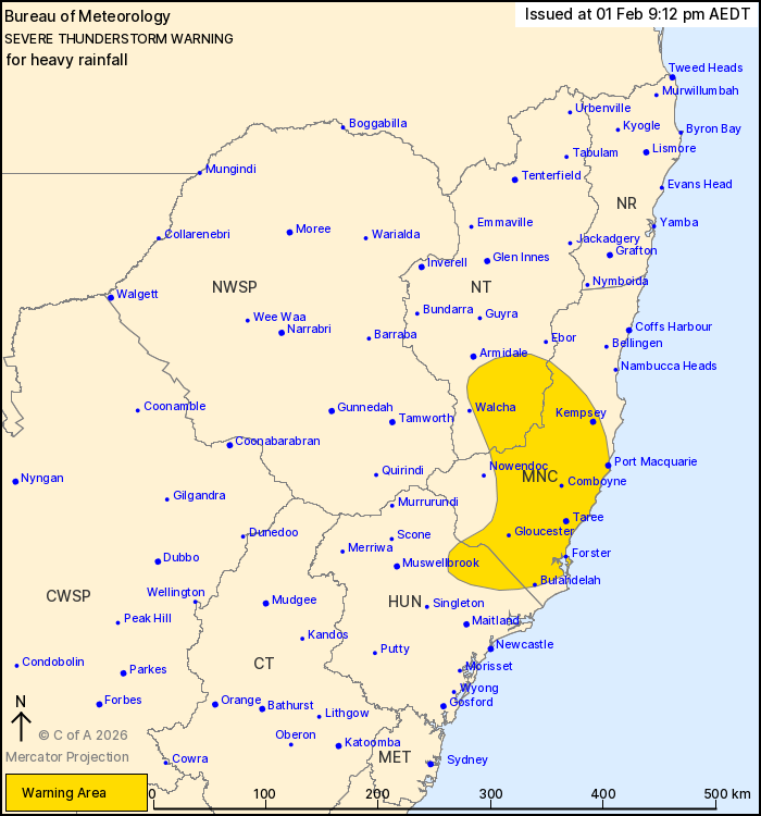
For people in parts of Mid North Coast, Hunter and Northern
Tablelands Forecast Districts.
Issued at 9:12 pm Sunday, 1 February 2026.
Severe thunderstorms with heavy rainfall about the Mid North Coast
and ranges this evening.
Weather Situation: A southerly change is interacting with the
ranges in an unstable airmass to generate isolated severe
thunderstorms this evening.
Severe thunderstorms are likely to produce heavy rainfall that may
lead to flash flooding in the warning area over the next several
hours. Locations which may be affected include Port Macquarie,
Taree, Kempsey, Comboyne, Gloucester and Forster.
55.2 mm was recorded at the Barrington Tops in the 2 hours to 9:10
pm.
44 mm was recorded at Upper Allyn Township in the 1 hour 20
minutes to 8:58 pm.
The State Emergency Service advises that people should:
* Keep clear of creeks and storm drains.
* Don't walk, ride your bike or drive through flood water.
* If you are trapped by flash flooding, seek refuge in the highest
available place and ring 000 if you need rescue.
* Stay indoors away from windows, and keep children and pets
indoors as well.
For emergency help in flood and storms, ring the SES on 132
500.
Stay updated on the Hazards Near Me NSW app or the ACT ESA website
(https://esa.act.gov.au).
01/Feb/2026 10:17 AM


