
Source: Bureau of Meteorology
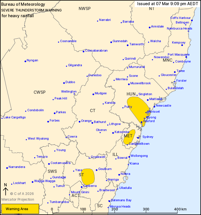
For people in parts of Hunter, Metropolitan and Southern
Tablelands Forecast Districts.
Issued at 9:09 pm Saturday, 7 March 2026.
Heavy rainfall developing in western Sydney this evening.
Weather Situation: A trough of low-pressure combines with
exceptionally high atmospheric moisture to produce slow moving
thunderstorms with heavy rainfall over parts of the ACT and central
eastern New South Wales.
Severe thunderstorms are likely to produce heavy rainfall that may
lead to flash flooding in the warning area over the next several
hours. Locations which may be affected include Gosford, Morisset,
Wyong, Cessnock, Parramatta and Toronto.
Severe thunderstorms are no longer occurring in the Central
Tablelands, South West Slopes and Australian Capital Territory
districts and the warning for these districts is CANCELLED.
Significant rainfall observations:
40.0 mm at Wingen in the 1 hour to 6:21 pm.
42.0 mm at Dungog in the 30 minutes to 5:33 pm.
43.0 mm at Yalwal in the 30 minutes to 4:50 pm.
51.4 mm at Parkes in the 1 hour to 4:11 pm.
The State Emergency Service advises that people should:
* Keep clear of creeks and storm drains.
* Don't walk, ride your bike or drive through flood water.
* If you are trapped by flash flooding, seek refuge in the highest
available place and ring 000 if you need rescue.
* Stay indoors away from windows, and keep children and pets
indoors as well.
For emergency help in flood and storms, ring the SES on 132
500.
Stay updated on the Hazards Near Me NSW app or the ACT ESA website
(https://esa.act.gov.au).
07/Mar/2026 10:16 AM

