
Source: Bureau of Meteorology
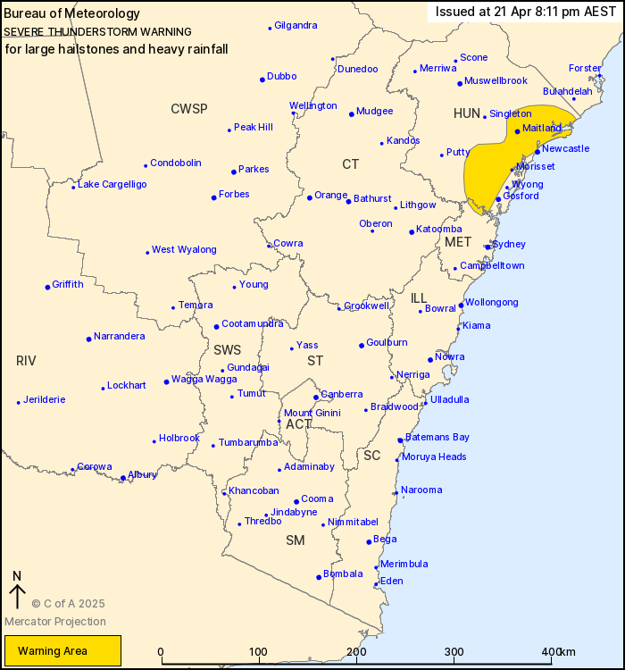
For people in parts of Hunter and Metropolitan Forecast
Districts.
Issued at 8:11 pm Monday, 21 April 2025.
Severe thunderstorms across parts of eastern NSW.
Weather Situation: An upper trough is moving through central and
northeast parts of NSW and is destabilising the atmosphere, thereby
aiding in thunderstorm development across eastern parts of the
state.
Severe thunderstorms are likely to produce large hailstones and
heavy rainfall that may lead to flash flooding in the warning area
over the next several hours. Locations which may be affected
include Maitland, Wallsend, Toronto, Morisset, Wollombi and
Kulnura.
Severe thunderstorms are no longer occurring in the Illawarra and
South Coast districts and the warning for these districts is
CANCELLED.
53.5mm was recorded at Lake Conjola in the 60 min to 6:52
pm.
41 mm was recorded at Ulladulla in the 30 min to 6:05 pm.
55.5 mm was recorded at Oranmeir in the 3 hours to 4:35 pm.
The State Emergency Service advises that people should:
* Move your car under cover.
* Keep clear of creeks and storm drains.
* Don't walk, ride your bike or drive through flood water.
* If you are trapped by flash flooding, seek refuge in the highest
available place and ring 000 if you need rescue.
* Be aware that run-off from rainfall in fire affected areas may
behave differently and be more rapid. It may also contain debris
such as ash, soil, trees and rocks.
* After bushfires, heavy rain and the loss of foliage can make the
ground soft and heavy, leading to a greater chance of
landslides.
* Unplug computers and appliances.
* Avoid using the phone during the storm.
* Stay indoors away from windows, and keep children and pets
indoors as well.
* Stay vigilant and monitor conditions. Note that the landscape
may have changed following bushfires.
* For emergency help in floods and storms, ring the SES (NSW and
ACT) on 132 500.
21/Apr/2025 10:20 AM


