
Source: Bureau of Meteorology
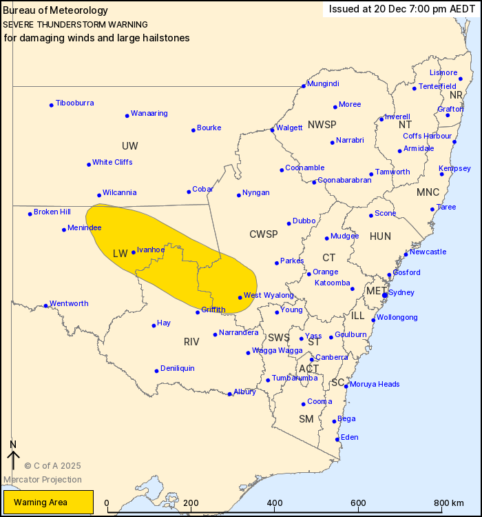
For people in parts of Central West Slopes and Plains, Riverina,
Lower Western and Upper Western Forecast Districts.
Issued at 7:00 pm Saturday, 20 December 2025.
Thunderstorms about the central interior of NSW.
Weather Situation: A hot and unstable airmass about a surface
trough is producing thunderstorms this afternoon that are likely to
persist into the evening.
Severe thunderstorms are likely to produce damaging winds and
large hailstones in the warning area over the next several hours.
Locations which may be affected include West Wyalong, Ivanhoe, Lake
Cargelligo and Hillston.
The State Emergency Service advises that people should:
* Park your car under secure cover and away from trees, powerlines
and drains.
* Secure or put away loose items around your house, yard and
balcony.
* Keep at least 8 metres away from fallen power lines or objects
that may be energised, such as fences.
* Report fallen power lines to either Ausgrid (131 388), Endeavour
Energy (131 003), Essential Energy (132 080) or Evoenergy (131 093)
as shown on your power bill.
* Stay indoors away from windows, and keep children and pets
indoors as well.
For emergency help in flood and storms, ring the SES on 132
500.
Stay updated on the Hazards Near Me NSW app or the ACT ESA website
(https://esa.gov.au).
20/Dec/2025 08:04 AM

