
Source: Bureau of Meteorology
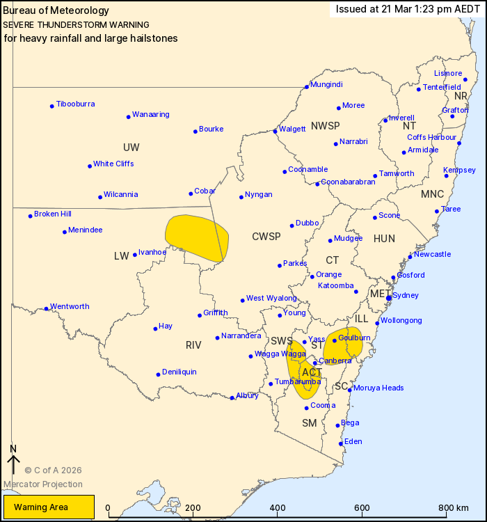
For people in Australian Capital Territory and parts of Illawarra,
Southern Tablelands, South West Slopes, Lower Western, Snowy
Mountains, South Coast, Central West Slopes and Plains and Riverina
Forecast Districts.
Issued at 1:23 pm Saturday, 21 March 2026.
Severe thunderstorms with heavy rainfall and possible large hail
continuing to develop.
Weather Situation: An upper-level trough combines with a trough of
low pressure over the southern half of the state today to produce
slow moving thunderstorms. Storms are moving slowly towards the
northeast and further warning expansions are likely over the
remainder of the afternoon.
Severe thunderstorms are likely to produce heavy rainfall that may
lead to flash flooding and possible large hailstones over the next
several hours in the Australian Capital Territory and parts of the
Illawarra, Southern Tablelands, South West Slopes, Snowy Mountains
and South Coast districts. Locations which may be affected include
Goulburn, Nerriga, Mount Ginini, Tidbinbilla, Bredbo and
Adaminaby.
Severe thunderstorms are likely to produce heavy rainfall that may
lead to flash flooding over the next several hours in parts of the
Lower Western, Central West Slopes and Plains and Riverina
districts.
The State Emergency Service advises that people should:
* Park your car under secure cover and away from trees, powerlines
and drains.
* Secure or put away loose items around your house, yard and
balcony.
* Keep clear of creeks and storm drains.
* Don't walk, ride your bike or drive through flood water.
* If you are trapped by flash flooding, seek refuge in the highest
available place and ring 000 if you need rescue.
* Stay indoors away from windows, and keep children and pets
indoors as well.
For emergency help in flood and storms, ring the SES on 132
500.
Stay updated on the Hazards Near Me NSW app or the ACT ESA website
(https://esa.act.gov.au).
21/Mar/2026 02:35 AM

