
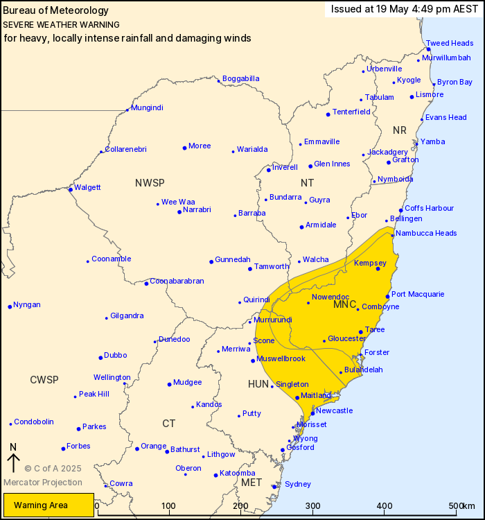
Source: Bureau of Meteorology
For people in Mid North Coast and parts of Hunter, Northern
Tablelands and North West Slopes and Plains Forecast
Districts.
Issued at 4:49 pm Monday, 19 May 2025.
HEAVY, LOCALLY INTENSE RAINFALL AND DAMAGING WINDS CONTINUING
ABOUT THE NORTHERN HUNTER AND THE MID NORTH COAST.
Weather Situation: A coastal trough currently positioned about the
southern Mid North Coast is forecast to slowly track northwards
into Tuesday, with heavy, locally intense rainfall and possible
damaging winds expected on the southern side of the trough.
Damaging winds are likely to ease during Tuesday, while heavy,
locally intense rainfall may continue into Wednesday.
Prolonged moderate rainfall with isolated areas of HEAVY RAINFALL
which may lead to FLASH FLOODING is forecast to continue for parts
of the Mid North Coast, northern Hunter and adjacent parts of the
North West Slopes & Plains and Northern Tablelands districts.
Six-hourly rainfall totals between 60 and 100 mm are likely, with
isolated totals up to 140 mm possible. 24-hourly rainfall totals
between 90 and 130 mm are likely, with isolated totals up to 200 mm
possible. Moderate to HEAVY RAINFALL is forecast to shift further
north into the Mid North Coast on Tuesday, possibly continuing into
Wednesday.
Locally INTENSE RAINFALL which may lead to DANGEROUS AND
LIFE-THREATENING FLASH FLOODING is also possible with persistent
heavy showers and isolated thunderstorms over coastal areas between
Seal Rocks and Nambucca Heads, as well as inland elevated parts of
the Mid North Coast district.
Southeasterly DAMAGING WINDS averaging 60 to 70 km/h with peak
gusts of around 90 km/h are possible over coastal areas between
Nelson Bay and Nambucca Heads for the remainder of today and into
Tuesday. Damaging winds are expected to ease below warning
thresholds by late Tuesday afternoon.
A Flood Watch and various Flood Warnings are current for multiple
catchments. A separate warning for DAMAGING SURF is also current
for the Hunter and Mid North Coast. Please refer to
http://www.bom.gov.au/nsw/warnings/.
Locations which may be affected include Newcastle, Port Macquarie,
Taree, Wingham, Nelson Bay, Dungog and Yarrowitch.
130 mm of rainfall was recorded at Port Macquarie in the 6 hours
to 3:40 pm.
70 km/h sustained winds were recorded at Norah Head around 10:00
am.
94 km/h wind gust was recorded at Nobby's Signal Station at 7:30
am.
The State Emergency Service advises that people should:
* Don't drive, ride or walk through flood water.
* Keep clear of creeks and storm drains.
* If you are trapped by flash flooding, seek refuge in the highest
available place and ring 000 if you need rescue.
* Be aware that run-off from rainfall in fire affected areas may
behave differently and be more rapid. It may also contain debris
such as ash, soil, trees and rocks.
* After bushfires, heavy rain and the loss of foliage can make the
ground soft and heavy, leading to a greater chance of
landslides.
* Move vehicles under cover or away from trees.
* Secure or put away loose items around your house, yard and
balcony.
* Keep at least 8 metres away from fallen power lines or objects
that may be energised, such as fences.
* Trees that have been damaged by fire are likely to be more
unstable and more likely to fall.
* Report fallen power lines to either Ausgrid (131 388), Endeavour
Energy (131 003), Essential Energy (132 080) or Evoenergy (131 093)
as shown on your power bill.
* Stay vigilant and monitor conditions. Note that the landscape
may have changed following bushfires.
* For emergency help in floods and storms, ring your local SES
Unit on 132 500.
19/May/2025 06:56 AM


