
Source: Bureau of Meteorology
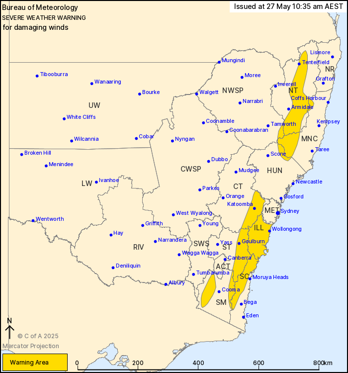
For people in Illawarra and parts of Mid North Coast, Hunter,
South Coast, Central Tablelands, Southern Tablelands, Snowy
Mountains, Northern Tablelands and North West Slopes and Plains
Forecast Districts.
Issued at 10:35 am Tuesday, 27 May 2025.
Damaging winds developing today along the Great Dividing Range and
Illawarra.
Weather Situation: A strong westerly flow has developed over
eastern New South Wales today behind a cold front that swept across
the state overnight.
For the ILLAWARRA, SOUTHERN RANGES, and BLUE MOUNTAINS: DAMAGING
WINDS averaging 50 to 65 km/h with peak gusts of around 90 km/h are
possible today. Winds are expected to ease below warning thresholds
about coastal parts of the Illawarra and South Coast districts by
early evening, before easing over inland elevated areas by late
tonight.
For the NORTHERN RANGES including the BARRINGTON TOPS AND NORTHERN
TABLELANDS: DAMAGING WINDS averaging 55 to 65 km/h with peak gusts
of around 90 km/h are possible today. Winds are expected to ease
below warning thresholds overnight into the early hours of
Wednesday morning.
Locations which may be affected include Wollongong, Nowra, Bowral,
Tenterfield, Katoomba and Goulburn.
91 km/h wind gust recorded at Cabramurra at 1:39am.
The State Emergency Service advises that people should:
* Move vehicles under cover or away from trees.
* Secure or put away loose items around your house, yard and
balcony.
* Keep at least 8 metres away from fallen power lines or objects
that may be energised, such as fences.
* Trees that have been damaged by fire are likely to be more
unstable and more likely to fall.
* Report fallen power lines to either Ausgrid (131 388), Endeavour
Energy (131 003), Essential Energy (132 080) or Evoenergy (131 093)
as shown on your power bill.
* Stay vigilant and monitor conditions. Note that the landscape
may have changed following bushfires.
* For emergency help in floods and storms, ring your local SES
Unit on 132 500.
27/May/2025 12:42 AM


