
Source: Bureau of Meteorology
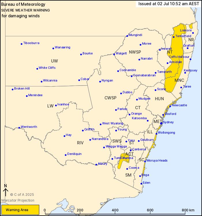
For people in parts of Northern Rivers, Mid North Coast, Hunter,
Metropolitan, Illawarra, South Coast, Snowy Mountains, Australian
Capital Territory, Northern Tablelands and South West Slopes
Forecast Districts.
Issued at 10:52 am Wednesday, 2 July 2025.
Damaging winds with a vigorous coastal low persisting about
eastern NSW and southern ACT.
Weather Situation: A mature low-pressure system is currently
located offshore of the southern Mid North Coast, and is forecast
to gradually track northeastwards into the Tasman Sea throughout
today. However, a secondary lobe of the complex low will approach
southern coasts into the evening, leading to a renewed burst of
damaging winds about coastal localities. Winds are expected to ease
as the entire low system tracks further east into the Tasman during
Thursday morning.
DAMAGING SOUTH TO SOUTHWESTERLY WINDS averaging 60 to 70 km/h with
peak gusts of around 100 km/h are possible today along parts of the
coastal fringe from the South Coast through to the Mid North Coast,
including Wollongong, eastern Sydney Metropolitan and Newcastle.
Winds are expected to ease below warning thresholds during Thursday
morning.
DAMAGING SOUTH TO SOUTHWESTERLY WIND GUSTS around 90 km/h are
possible for parts of the Snowy Mountains and southern ACT this
morning, easing below warning thresholds during the
afternoon.
Strong to DAMAGING WEST TO SOUTHWESTERLY WINDS averaging 55 to 65
km/h with peak gusts of around 100 km/h are likely about parts of
the Northern Tablelands, the Mid North Coast hinterland and about
the Border Ranges, and are expected to continue through to Thursday
morning.
A separate Coastal Hazard Warning is also current for parts of the
NSW coast. Refer to: http://www.bom.gov.au/nsw/warnings/
Locations which may be affected include eastern Sydney
Metropolitan, Newcastle, Wollongong, Tenterfield, Mt Ginini and
Moruya Heads.
Severe weather is no longer occurring in the Southern Tablelands
district and the warning for this district is CANCELLED.
Significant rainfall observations:
88.5 mm was recorded at Oranmeir in the 6 hours to 3:22 am.
108 mm was recorded at Nowra in the 6 hours to 12:02 am.
133 mm was recorded at Morton in the 6 hours to 11:43 pm.
116 mm was recorded at Vincentia in the 6 hours to 9:37 pm.
121 mm was recorded at Greenwell Point in the 6 hours to 9:10
pm.
112 mm was recorded at Currarong in the 6 hours to 8:42 pm.
Significant wind observations:
100 km/h gust was recorded at Kiama at 5:57 am.
102 km/h gust was recorded at Wedding Cake at 5:43 am.
94 km/h gust was recorded at Sydney Airport at 5:35 am.
91 km/h gust was recorded at Moss Vale at 5:31 am.
98 km/h gust was recorded at Kurnell at 5:25 am.
102 km/h gust was recorded at Bellambi at 4:37 am.
100 km/h gust was recorded at Jervis Bay Airfield at 7:36
pm.
102 km/h gust was recorded at Point Perpendicular at 7:33
pm.
104 km/h gust was recorded at Ulladulla at 7:21 pm.
93 km/h gust was recorded at Wanganderry at 7:04 pm.
102 km/h gust was recorded at Penrith at 6:27 pm.
91 km/h gust was recorded at Wollongong at 6:21 pm.
93 km/h gust was recorded at Nowra at 5:45 pm.
The State Emergency Service advises that people should:
* Move vehicles under cover or away from trees.
* Secure or put away loose items around your house, yard and
balcony.
* Keep at least 8 metres away from fallen power lines or objects
that may be energised, such as fences.
* Trees that have been damaged by fire are likely to be more
unstable and more likely to fall.
* Report fallen power lines to either Ausgrid (131 388), Endeavour
Energy (131 003), Essential Energy (132 080) or Evoenergy (131 093)
as shown on your power bill.
* Stay vigilant and monitor conditions. Note that the landscape
may have changed following bushfires.
* For emergency help in floods and storms, ring your local SES
Unit on 132 500.
02/Jul/2025 01:05 AM

