
Source: Bureau of Meteorology
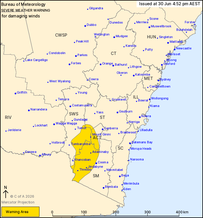
For people in parts of South West Slopes, Snowy Mountains,
Australian Capital Territory and Southern Tablelands Forecast
Districts.
Issued at 4:52 pm Tuesday, 30 June 2026.
Damaging winds to develop on Wednesday evening for alpine
areas.
Weather Situation: A fast moving cold front will move through the
state on Wednesday afternoon. Strong winds aloft ahead of the front
will reach the elevated terrain from early evening. The winds are
expected to contract and ease in the wake of the front but remain
locally strong over the Snowy Mountains into Thursday.
For the SNOWY MOUNTAINS and BRINDABELLAS above 1200 metres:
DAMAGING WINDS averaging 60 to 70 km/h with peak gusts around 110
km/h are likely to develop from Wednesday evening and persist for
several hours. From midnight winds are expected to decrease to 50
to 60 km/h with gusts up to 90 km/h in the Snowy Mountains, but
ease over the Brindabellas.
For ALPINE AREAS above 1900 metres: DAMAGING WINDS averaging 80 to
90 km/h with peak gusts in excess of 125 km/h are likely to develop
from Wednesday evening and persist for several hours. Winds are
expected to ease early Thursday morning.
Locations which may be affected include Mount Ginini, Thredbo,
Tidbinbilla and Perisher Valley.
The State Emergency Service advises that people should:
* Park your car under secure cover and away from trees, powerlines
and drains.
* Secure or put away loose items around your house, yard and
balcony.
* Keep at least 8 metres away from fallen power lines or objects
that may be energised, such as fences.
* Report fallen power lines to either Ausgrid (131 388), Endeavour
Energy (131 003), Essential Energy (132 080) or Evoenergy (131 093)
as shown on your power bill.
For emergency help in flood and storms, ring the SES on 132
500.
Stay updated on the Hazards Near Me NSW app or the ACT ESA website
(https://esa.act.gov.au).
30/Jun/2026 06:58 AM

