
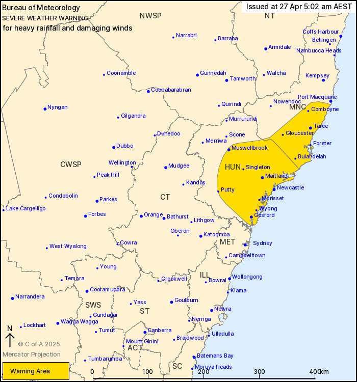
Source: Bureau of Meteorology
For people in parts of Mid North Coast and Hunter Forecast
Districts.
Issued at 5:02 am Sunday, 27 April 2025.
Areas of heavy rain developing about the southern Mid North Coast
and eastern Hunter this morning. Damaging winds possible about
parts of the exposed coast from late morning.
Weather Situation: An upper level low over central inland NSW will
move eastwards towards the coast today. A low pressure system near
the southern Mid North Coast is expected to move southwards along
the coastline through today, while gradually deepening. The
development of the low will enhance the moist and unstable onshore
flow, supporting bands of heavy rain and thunderstorms. Winds will
also strengthen around the exposed coast from this afternoon as the
low deepens. The low is expected to begin moving slowly eastwards
taking it further offshore from this afternoon and evening.
HEAVY RAINFALL which may lead to FLASH FLOODING is expected about
the southern Mid North Coast in the next few hours, and is likely
to shift southwards to the Hunter later this morning. Six-hourly
rainfall totals between 75 and 100 mm are likely, with isolated
falls of 140 mm possible. These conditions are expected to ease
during this afternoon.
South to southeasterly winds with DAMAGING WIND GUSTS and peak
gusts of around 90 km/h are possible about the coast of the Hunter
and southern Mid North Coast from late morning into the early
evening, before easing later in the evening today.
A Flood Watch and several Flood Warnings are current over the
area, for further details see
http:/www.bom.gov.au/nsw/warnings
Locations which may be affected include Taree, Newcastle, Gosford,
Cessnock, Maitland, Putty, Wollombi, Dungog and Kulnura.
117 mm was recorded at Collombatti in the 6 hours to 2:10
am.
75 mm was recorded at Majors Creek (Moparrabah) in the 3 hours to
1:10 am.
The State Emergency Service advises that people should:
* Don't drive, ride or walk through flood water.
* Keep clear of creeks and storm drains.
* If you are trapped by flash flooding, seek refuge in the highest
available place and ring 000 if you need rescue.
* Be aware that run-off from rainfall in fire affected areas may
behave differently and be more rapid. It may also contain debris
such as ash, soil, trees and rocks.
* After bushfires, heavy rain and the loss of foliage can make the
ground soft and heavy, leading to a greater chance of
landslides.
* Move vehicles under cover or away from trees.
* Secure or put away loose items around your house, yard and
balcony.
* Keep at least 8 metres away from fallen power lines or objects
that may be energised, such as fences.
* Trees that have been damaged by fire are likely to be more
unstable and more likely to fall.
* Report fallen power lines to either Ausgrid (131 388), Endeavour
Energy (131 003), Essential Energy (132 080) or Evoenergy (131 093)
as shown on your power bill.
* Stay vigilant and monitor conditions. Note that the landscape
may have changed following bushfires.
* For emergency help in floods and storms, ring your local SES
Unit on 132 500.
26/Apr/2025 07:19 PM


