
Source: Bureau of Meteorology
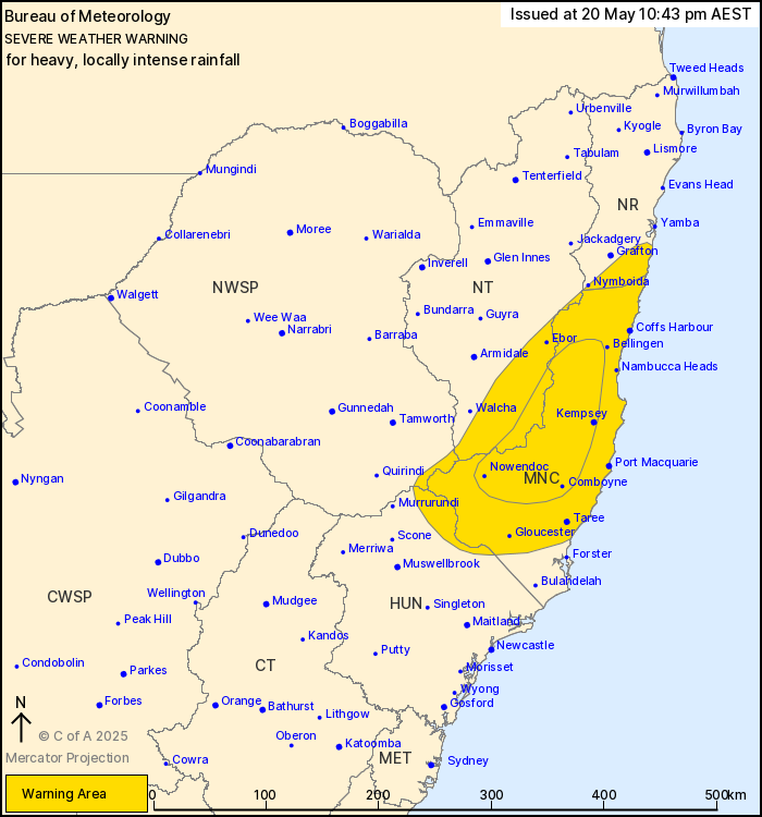
For people in Mid North Coast and parts of Northern Rivers,
Hunter, Northern Tablelands and North West Slopes and Plains
Forecast Districts.
Issued at 10:43 pm Tuesday, 20 May 2025.
HEAVY, LOCALLY INTENSE RAINFALL CONTINUING ABOUT THE MID NORTH
COAST.
Weather Situation: A coastal trough is currently positioned about
the central Mid North Coast, and it is forecast to track slowly
northwards this evening to around Coffs Harbour before continuing
towards Grafton on Wednesday. Heavy, locally intense rainfall is
expected to persist with heavy showers and isolated thunderstorms
on the southern side of the trough for the remainder of tonight and
into Wednesday.
Prolonged moderate rainfall with isolated areas of HEAVY RAINFALL
which may lead to FLASH FLOODING is forecast to continue for parts
of the Mid North Coast, northern Hunter and adjacent parts of the
North West Slopes & Plains and Northern Tablelands districts.
Six-hourly rainfall totals between 50 and 80 mm are likely.
24-hourly rainfall totals between 80 and 120 mm are likely.
Moderate to HEAVY RAINFALL is forecast to gradually shift further
north through the Mid North Coast this evening and during
Wednesday, reaching southern parts of the Northern Rivers on
Wednesday afternoon.
Locally INTENSE RAINFALL which may lead to DANGEROUS AND
LIFE-THREATENING FLASH FLOODING is also possible for the remainder
of today and during Wednesday morning for elevated inland parts of
the Mid North Coast district. Six-hourly rainfall totals between
100 and 140 mm are possible. 24-hourly rainfall totals between 150
and 200 mm are possible.
A Flood Watch and various Flood Warnings are current for multiple
catchments. A separate warning for DAMAGING SURF is also current
for the Mid North Coast. Please refer to
http://www.bom.gov.au/nsw/warnings/.
Locations which may be affected include Coffs Harbour, Port
Macquarie, Taree, Kempsey, Woolgoolga, Sawtell, Dorrigo, Wingham
and Yarrowitch.
Significant rainfall observations to 10:30 pm Tuesday
include:
190 MM WAS RECORDED AT TAREE AIRPORT IN THE 6 HOURS TO 3:34
AM.
109 mm was recorded at Moparrabah in the 6 hours to 8:41 pm.
118.4 mm was recorded at Mount Seaview in the 6 hours to 7:30
pm.
135 mm was recorded at Turner's Flat in the 6 hours to 4:00
pm.
77 mm was recorded at Cooplacurripa in the 6 hours to 9:43
am.
124 mm was recorded at Mooral Creek in the 6 hours to 9:38
am.
102 mm was recorded at Killabakh in the 6 hours to 8:14 am.
81 mm was recorded at Moppy Lookout (Barrington Tops) in the 6
hours to 6:43 am.
101.8 mm was recorded at Rocks Crossing in the 6 hours to 5:52
am.
101 mm was recorded at Mount Barrington in the 6 hours to 1:33
am.
94.8 mm was recorded at Carey's Peak (Barrington Tops) in the 6
hours to 1:28 am.
The State Emergency Service advises that people should:
* Don't drive, ride or walk through flood water.
* Keep clear of creeks and storm drains.
* If you are trapped by flash flooding, seek refuge in the highest
available place and ring 000 if you need rescue.
* Be aware that run-off from rainfall in fire affected areas may
behave differently and be more rapid. It may also contain debris
such as ash, soil, trees and rocks.
* After bushfires, heavy rain and the loss of foliage can make the
ground soft and heavy, leading to a greater chance of
landslides.
* Stay vigilant and monitor conditions. Note that the landscape
may have changed following bushfires.
* For emergency help in floods and storms, ring your local SES
Unit on 132 500.
20/May/2025 12:50 PM

