
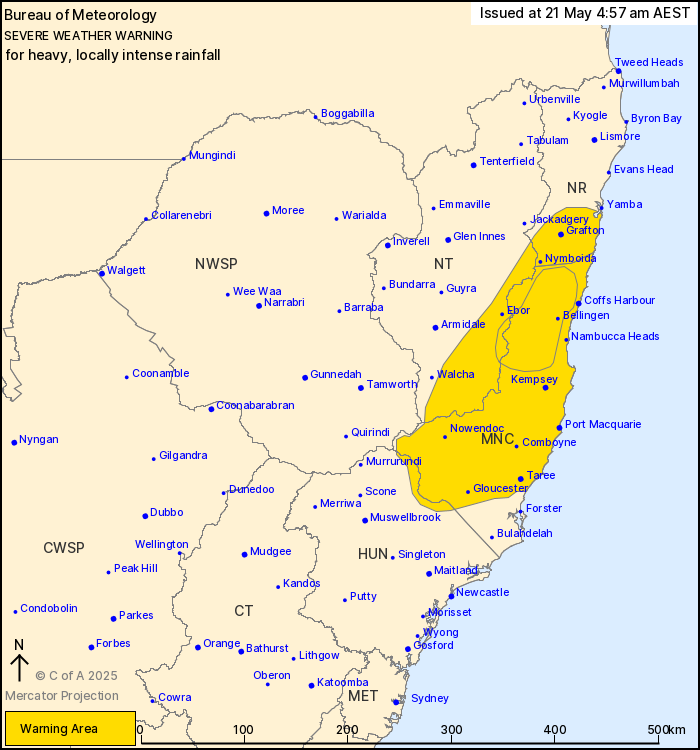
Source: Bureau of Meteorology
For people in Mid North Coast and parts of Northern Rivers,
Northern Tablelands and Hunter Forecast Districts.
Issued at 4:57 am Wednesday, 21 May 2025.
HEAVY, LOCALLY INTENSE RAINFALL CONTINUING ABOUT THE MID NORTH
COAST.
Weather Situation: A coastal trough in the vicinity of Coffs
Harbour will track slowly northwards into southern parts of the
Northern Rivers district today. A persistent and very moist onshore
flow to the south of this trough will continue to trigger
widespread areas of rain across the region, with embedded heavy
showers and thunderstorms. Areas of heavy rainfall are expected to
persist into Thursday as the trough moves to the south once
more.
Prolonged moderate rainfall with isolated areas of HEAVY RAINFALL
which may lead to FLASH FLOODING is forecast to continue for parts
of the Mid North Coast, northern Hunter and adjacent parts of the
Northern Tablelands districts. Six-hourly rainfall totals between
50 and 100 mm are likely. 24-hourly rainfall totals between 80 and
150 mm are likely. Moderate to HEAVY RAINFALL is forecast to
gradually shift further north into southern parts of the Northern
Rivers district by this afternoon.
Locally INTENSE RAINFALL which may lead to DANGEROUS AND
LIFE-THREATENING FLASH FLOODING is also possible for elevated
inland parts of the Mid North Coast district north of about South
West Rocks, more likely from this evening and into Thursday
morning. Six-hourly rainfall totals between 100 and 150 mm are
possible. 24-hourly rainfall totals between 200 and 300 mm are
possible.
A Flood Watch and various Flood Warnings are current for multiple
catchments. Please refer to
http://www.bom.gov.au/nsw/warnings/.
Locations which may be affected include Grafton, Coffs Harbour,
Port Macquarie, Taree, Sawtell and Dorrigo.
Severe weather is no longer occurring in the North West Slopes and
Plains district and the warning for this district is
CANCELLED.
Significant rainfall observations since 9am Tuesday include:
248 mm at Moparrabah, including 109 mm in 6 hours to 8:41
pm.
254 mm at Mt Seaview, including 118.4 mm in the 6 hours to 7:30
pm.
205 mm at Comboyne Public School.
199 mm at Moppy Lookout (Barrington Tops).
193 mm at Turners Flat.
165 mm at Kooroowi.
The State Emergency Service advises that people should:
* Don't drive, ride or walk through flood water.
* Keep clear of creeks and storm drains.
* If you are trapped by flash flooding, seek refuge in the highest
available place and ring 000 if you need rescue.
* Be aware that run-off from rainfall in fire affected areas may
behave differently and be more rapid. It may also contain debris
such as ash, soil, trees and rocks.
* After bushfires, heavy rain and the loss of foliage can make the
ground soft and heavy, leading to a greater chance of
landslides.
* Stay vigilant and monitor conditions. Note that the landscape
may have changed following bushfires.
* For emergency help in floods and storms, ring your local SES
Unit on 132 500.
20/May/2025 08:24 PM


