
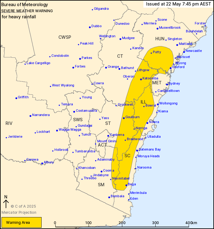
Source: Bureau of Meteorology
For people in Illawarra and parts of Hunter, Metropolitan, South
Coast, Central Tablelands, Southern Tablelands and Snowy Mountains
Forecast Districts.
Issued at 7:45 pm Thursday, 22 May 2025.
Heavy rainfall has eased in the Mid North Coast but will continue
over central and southern parts of the Great Dividing Range.
Weather Situation: The coastal trough along the Mid North Coast
has weakened and conditions in that region have now eased to
moderate showers. Further south, a persistent and very moist
onshore flow continues to bring area of widespread rain with
embedded heavy showers, particularly over the Great Dividing Range.
Heavy rainfall is expected over inland parts of the southern
Hunter, Blue Mountains and Southern Highlands this evening, which
will extend further south to the Southern Tablelands and inland
parts of the South Coast during Friday.
Ongoing moderate rainfall increasing to areas of HEAVY RAINFALL
which may lead to FLASH FLOODING is expected over parts of Great
Dividing Range to the north of Goulburn this evening, this includes
the Blue Mountains and Southern Highlands. HEAVY RAINFALL will then
extend to remaining parts of the warning area over the Southern
Tablelands, Snowy Mountains and inland South Coast district during
Friday. Six-hourly rainfall totals of 60 to 90 mm are possible with
24-hourly totals between 100 and 150 mm.
Rainfall is expected to ease gradually from the north, through
central parts of the state during late Friday afternoon or evening,
before easing over the southeast during Saturday morning.
Locations which may be affected include Bowral, Braidwood, Bega,
Katoomba, Goulburn, Jenolan Caves, Springwood, Bilpin, Taralga,
Araluen, Nerriga and Captains Flat.
Severe weather is no longer occurring in the Mid North Coast and
Northern Tablelands districts and the warning for these districts
is CANCELLED.
A Flood Watch and various Flood Warnings are current for multiple
catchments in the state and a Damaging Surf Warning is also current
for coastal areas of the Mid North Coast. Please refer to
http://www.bom.gov.au/nsw/warnings/
Significant rainfall observations between 9:00 am and 7:00 pm
Thursday include:
96.6 mm at Richmond Airport.
85.0 mm at Tallong.
81.5 mm at Utungun (Taylors Arm).
67.0 mm at Bowraville.
The State Emergency Service advises that people should:
* Don't drive, ride or walk through flood water.
* Keep clear of creeks and storm drains.
* If you are trapped by flash flooding, seek refuge in the highest
available place and ring 000 if you need rescue.
* Be aware that run-off from rainfall in fire affected areas may
behave differently and be more rapid. It may also contain debris
such as ash, soil, trees and rocks.
* After bushfires, heavy rain and the loss of foliage can make the
ground soft and heavy, leading to a greater chance of
landslides.
* Stay vigilant and monitor conditions. Note that the landscape
may have changed following bushfires.
* For emergency help in floods and storms, ring your local SES
Unit on 132 500.
22/May/2025 09:50 AM

