
Source: Bureau of Meteorology
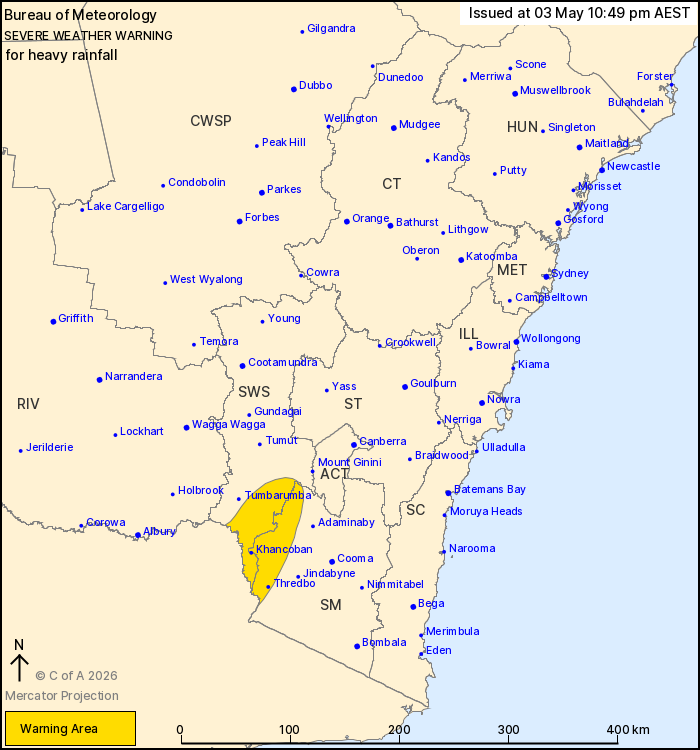
For people in parts of South West Slopes and Snowy Mountains
Forecast Districts.
Issued at 10:49 pm Sunday, 3 May 2026.
Heavy rainfall possible about alpine areas overnight, easing
Monday morning.
Weather Situation: A cold front and associated upper-level
disturbance is moving through southern New South Wales. A
strengthening frontal cloud band over southern New South Wales,
combined with rich atmospheric moisture, is producing areas of rain
and showers.
HEAVY RAINFALL which may lead to FLASH FLOODING is forecast for
the alpine areas of the Snowy Mountains and adjacent areas of the
South West Slopes district overnight and early Monday morning.
Six-hourly rainfall totals up to 70 mm are possible. HEAVY RAINFALL
should ease below warning thresholds about sunrise on Monday.
Locations which may be affected include Thredbo, Khancoban,
Charlotte Pass, Cabramurra and Selwyn.
The State Emergency Service advises that people should:
* Don't drive, ride or walk through flood water.
* Keep clear of creeks and storm drains.
* If you are trapped by flash flooding, seek refuge in the highest
available place and ring 000 if you need rescue.
For emergency help in flood and storms, ring the SES on 132
500.
Stay updated on the Hazards Near Me NSW app or the ACT ESA website
(https://esa.act.gov.au).
03/May/2026 01:05 PM

