
Source: Bureau of Meteorology
Issued at 4:29 pm ACST on Friday 15 March 2024
Headline:
Developing tropical low in the Gulf of Carpentaria bringing strong
winds and heavy rain, especially to the southwestern Gulf
coast.
Areas Affected:
Warning Zone
Alyangula (Groote Eylandt) in NT to the NT/Qld border, including
Borroloola but not including Ngukurr.
Watch Zone
NT/Qld border to Mornington Island, including Mornington Island.
Adjacent inland parts of the Carpentaria in the Northern
Territory.
Cancelled Zone
None.
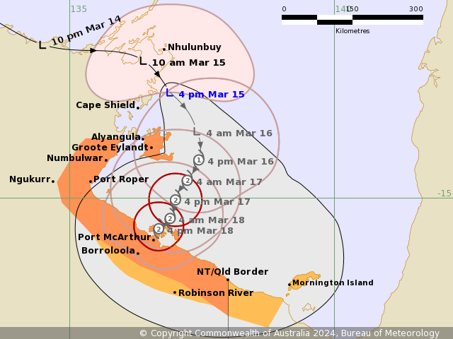
Details of Tropical Low at 3:30 pm ACST:
Intensity: Tropical Low, sustained winds near the centre of 75
kilometres per hour with wind gusts to 100 kilometres per
hour.
Location: within 20 kilometres of 13.0 degrees South 136.9 degrees
East, estimated to be 90 kilometres south of Nhulunbuy and 110
kilometres north northeast of Alyangula.
Movement: southeast at 14 kilometres per hour.
A tropical low, 09U, is currently located just offshore of
Nhulunbuy, and is moving to the southeast in the Gulf of
Carpentaria.
The low is forecast to develop to a tropical cyclone during
Saturday, to the east of Groote Eylandt. It is then forecast to
move slowly south towards the southwestern Gulf of Carpentaria
coast. It is most likely to cross the coast on Monday and weaken
quickly during Tuesday.
Hazards:
Gales with DAMAGING WIND GUSTS of 110 km/h may develop over Groote
Eylandt during Saturday morning.
Gales with DAMAGING WIND GUSTS of 100 km/hr may extend further to
the Northern Territory coast between Alyangula to the Northern
Territory/Queensland border, including Borroloola, from as early as
Saturday evening, though more likely during Sunday. These gales
will possibly extend inland to Robinson River on Sunday if the
system moves more quickly to the south.
Gales with DAMAGING WIND GUSTS of 100 km/hr are possible from the
Northern Territory/Queensland border to Mornington Island during
Sunday, depending on how far to the southeast the system
moves.
Destructive winds gusts are also possible for the southwestern
Gulf of Carpentaria coast, near the system centre from as early as
late Sunday.
HEAVY RAINFALL is occurring over northeastern parts of the Top
End. This will increase into the weekend, with the heaviest falls
limited to coastal and island locations on Saturday before reaching
further inland into the Carpentaria forecast districts into Sunday.
Later in the weekend, INTENSE RAINFALL is possible, especially
about coastal parts of the Carpentaria districts.
ABNORMALLY HIGH TIDES could cause MINOR FLOODING along the
southern Gulf of Carpentaria coast this weekend. Large waves may
produce minor flooding along the foreshore.
Recommended Action:
The Northern Territory Emergency Service advise:
For the communities in the area of the Cyclone Watch:
- Prepare now
- Stay informed
- Monitor conditions
For the communities in the area of the Cyclone Warning:
- Enact your household plan
- Prepare your property now
- Stay informed
- Monitor Take extra care on the roads
QFES advises:
People between the Queensland/ Northern Territory border and
Mornington Island, including Mornington Island should consider what
action they will need to take if the cyclone threat
increases.
- Information is available from your local government
- For cyclone preparedness and safety advice, visit Queensland's
Disaster Management Services website
(www.disaster.qld.gov.au)
- For emergency assistance call the Queensland State Emergency
Service (SES) on 132 500 (for assistance with storm damage, rising
flood water, fallen trees on buildings or roof damage).
Current
Tropical Cyclones
15/Mar/2024 07:18 AM


