
Source: Bureau of Meteorology
Issued at 12:07 pm AEST on Thursday 5 March 2026 Flood Watch
Number: 4
RIVER LEVEL RISES AND FLOODING POSSIBLE ACROSS THE FLOOD WATCH
AREA FROM THURSDAY
Tropical Low 29U is approaching the northeast coast during
Thursday. Heavy to locally intense rainfall is possible on the
North Tropical Coast on Thursday and Friday, with a forecast
crossing on Friday. Heavy rain is also possible throughout much of
the Cape York Peninsula and Gulf Country during the remainder of
the week and into the weekend.
Catchments across the Flood Watch area are wet to saturated with
recent rainfall. Further rainfall is likely to result in rapid
river level rises and flooding across the Flood Watch area.
Disruption to transport routes are likely across parts of the Flood
Watch area.
After the tropical low crosses the coast, moderate to locally
heavy rainfall is possible in eastern and central districts on the
weekend and Monday, including South East Queensland. Any heavy
rainfall is highly dependent on the path the tropical low remnants
take. At this stage there is very high uncertainty with the future
movements of this system. The situation is being monitored and this
Flood Watch or additional Flood Watches will be updated as
required.
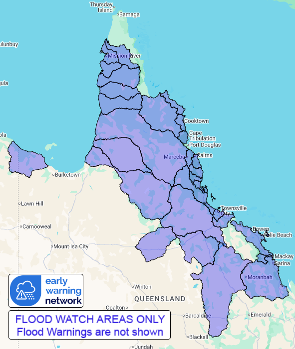
Catchments likely to be affected include:
Normanby River
Jeannie River
Endeavour River
Daintree River (for Bloomfield River. Warning current for
Daintree River and Mossman River)
Barron River
Mulgrave and Russell Rivers
Johnstone River
Tully River
Murray River
Herbert River
Black River (including Bluewater Creek)
Ross and Bohle Rivers
Haughton River
Belyando and Suttor Rivers to Burdekin Falls Dam
Cape River to Burdekin Falls Dam
Burdekin River to Burdekin Falls Dam
Don and Proserpine Rivers
Pioneer River
Connors, Isaac and Styx Rivers and Plane Creek
Settlement Creek
Upper Flinders River (warning current for Lower Flinders
River)
Gilbert River
Staaten River
Mitchell River (moderate flooding occurring along
Magnificent Creek at Kowanyama)
Coleman and Edward Rivers
Holroyd and Kendall Rivers
Archer and Coen Rivers
Watson River
Embley and Mission Rivers
Wenlock River
Flood warnings are current for the following catchment(s) :
Daintree, Mossman, lower Flinders, Norman. A Severe Weather Warning
for heavy rainfall is current for parts of Peninsula and North
Tropical Coast and Tablelands Forecast Districts.
Flooding is no longer expected in the following catchment(s):
Ducie, Jackson and Skardon and Jardine
For the latest flood and weather warnings see
www.bom.gov.au/weather-and-climate/warnings-and-alerts
For the latest rainfall and river level information see
www.bom.gov.au/australia/flood
Safety Advice:
* Don't drive, walk, swim or play in floodwater because it is
dangerous.
* Stay away from flooded drains, rivers, streams and
waterways.
* Obey road closure signs. Plan ahead so you don't drive on
flooded roads.
* Check the ABC and local media for updates. The situation can
change quickly, so stay informed.
* For local emergency management warnings and advice visit
www.disaster.qld.gov.au/warnings.
Rainfall and River
Conditions Map
05/Mar/2026 02:31 AM

