
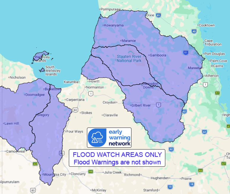
Source: Bureau of Meteorology
Flood Watch for parts of the Gulf of Carpentaria and Cape York
Peninsula
Issued at 12:42 pm AEST on Monday 23 February 2026
Flood Watch Number: 15
FLOODING LIKELY TO CONTINUE OVER THE NEXT FEW DAYS
Showers and thunderstorms will continue for several days across
the Flood Watch area, with moderate to locally heavy rainfall
possible.
Catchments are relatively wet to very wet after recent rainfall.
River and creek levels remain elevated across the Flood Watch area,
with further river level rises and additional areas of flooding
possible over the next few days.
Rapid river level rises and flash flooding remain possible in
areas that receive the heaviest rainfall. Road closures and
community isolation are occurring in some areas.
The situation will be monitored closely and Flood Warnings will be
issued as required.
Catchments likely to be affected include:
Nicholson River
Leichhardt River
Gilbert River
Staaten River
Mitchell River(Including Magnificent Creek at Kowanyama, where
major flooding is occurring)
Flood Warnings are current for numerous catchments across western,
central and northern Queensland. Flood Watches are current for
parts of South Australia, New South Wales and Northern Territory
for catchments bordering southwestern Queensland.
For the latest flood and weather warnings see
www.bom.gov.au/weather-and-climate/warnings-and-alerts
For the latest rainfall and river level information see
www.bom.gov.au/australia/flood
Safety Advice:
Don't drive, walk, swim or play in floodwater because it is
dangerous.
Stay away from flooded drains, rivers, streams and
waterways.
Obey road closure signs. Plan ahead so you don't drive on flooded
roads.
Check the ABC and local media for updates. The situation can
change quickly, so stay informed.
For local emergency management warnings and advice visit
www.disaster.qld.gov.au/warnings.
For emergency assistance call SES on telephone number 132 500. In
life-threatening emergencies, call 000 (triple zero)
immediately.
Rainfall and River
Conditions Map
23/Feb/2026 03:03 AM

