
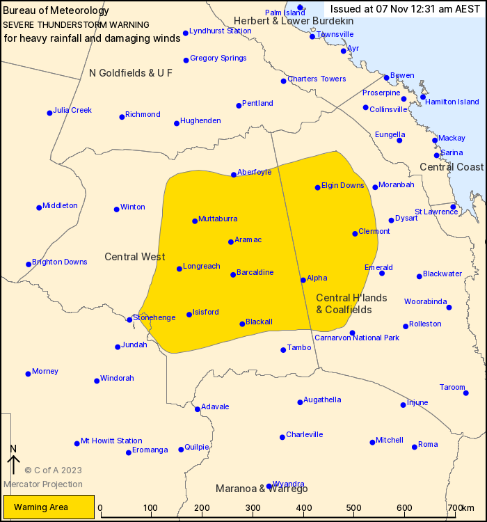
Source: Bureau of Meteorology
For people in parts of Central Highlands and Coalfields, Central
West and Channel Country Forecast Districts.
Issued at 12:31 am Tuesday, 7 November 2023.
Severe thunderstorms likely to continue over central inland
Queensland into the overnight period.
Weather Situation: A moist unstable airmass remains in place to
the east of a trough extending from about Hughenden southwards
through Longreach to the western Warrego. Increasing low level
winds into this trough, combined with an upper level trough over
the area, will both assist in the development and maintenance of
severe storms overnight.
Severe thunderstorms are likely to produce heavy rainfall that may
lead to flash flooding and damaging winds in the warning area over
the next several hours. Locations which may be affected include
Longreach, Clermont, Isisford, Barcaldine, Blackall and
Muttaburra.
Mt Playfair, east of Tambo, recorded 49 mm of rainfall in 1 hour
up to 6 pm.
Blackall Airport reported a wind gust of 83 km/h at 5:32 pm.
Queensland Fire and Emergency Services advises that people
should:
* Move your car under cover or away from trees.
* Secure loose outdoor items.
* Never drive, walk or ride through flood waters. If it's flooded,
forget it.
* Seek shelter, preferably indoors and never under trees.
* Avoid using the telephone during a thunderstorm.
* Beware of fallen trees and powerlines.
* For emergency assistance contact the SES on 132 500.
06/Nov/2023 02:36 PM

