
Source: Bureau of Meteorology
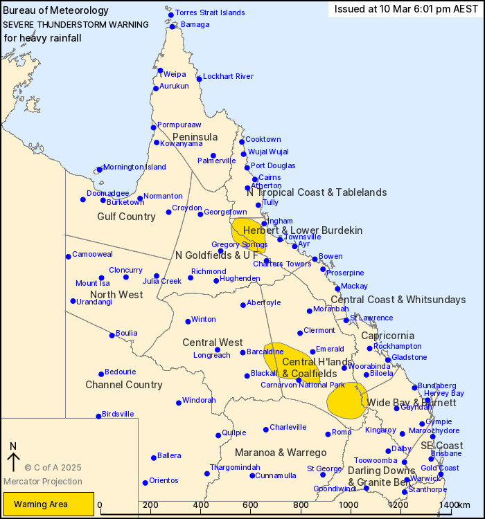
For people in parts of Northern Goldfields and Upper Flinders,
Herbert and Lower Burdekin, Central Highlands and Coalfields,
Central West, Capricornia, Wide Bay and Burnett and North Tropical
Coast and Tablelands Forecast Districts.
Issued at 6:01 pm Monday, 10 March 2025.
Severe thunderstorms continuing over the east into late
afternoon.
Weather Situation: Slow-moving storms in an extremely moist
atmosphere are continuing to produce heavy rainfall across coastal
areas and higher terrain in the east.
Severe thunderstorms are likely to produce heavy rainfall that may
lead to flash flooding in the warning area over the next several
hours. Locations which may be affected include Taroom, Springsure,
Theodore, Bogantungan, Mantuan Downs and Alpha.
Severe thunderstorms are no longer occurring in the Maranoa and
Warrego and Darling Downs and Granite Belt districts and the
warning for these districts is CANCELLED.
52.6 mm was recorded at Dooloogarah Alert in the hour to 4:30
pm.
78 mm was recorded at Durah Homestead Alert in the two hours to
15:53.
Emergency services advise people to:
* Park your car undercover away from trees.
* Close doors and windows.
* Keep asthma medications close by. Storms and wind can trigger
asthma attacks.
* Charge mobile phones and power banks in case the power goes
out.
* Put your pets somewhere safe and make sure they can be
identified in case they get lost.
* Do not drive now unless you have to because conditions are
dangerous.
* Tell friends, family and neighbours in the area.
* Go inside a strong building now. Stay inside until the storm has
passed.
10/Mar/2025 08:07 AM


