
Source: Bureau of Meteorology
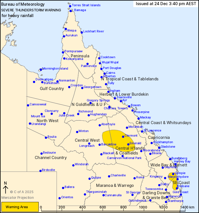
For people in parts of Central Highlands and Coalfields, Central
West, Wide Bay and Burnett and Southeast Coast Forecast
Districts.
Issued at 3:40 pm Wednesday, 24 December 2025.
Severe storms continue in the southeast and also the Central
Highlands this afternoon.
Weather Situation: A very moist atmosphere is in place over most
of the state extending from a low pressure system and developing
monsoon in place over the Northern Territory. Slow moving severe
thunderstorms have developed in this moist and unstable environment
and are likely to persist throughout the afternoon and into the
evening.
Severe thunderstorms are likely to produce heavy rainfall that may
lead to flash flooding in the warning area over the next several
hours. Locations which may be affected include Brisbane, Gympie,
Emerald, Clermont, Redcliffe and Caboolture.
Severe thunderstorms are no longer occurring in the Capricornia
and Darling Downs and Granite Belt districts and the warning for
these districts is CANCELLED.
60.mm was recorded at Jimna in the 30 minutes to 2:55pm.
55.4 mm was recorded at Billaboo in the 1 hour to 2:30pm.
78.0 mm was recorded at Cedar Vale (Central Queensland) in the 2
hours to 1:58 pm.
Emergency services advise people to:
* Park your car undercover away from trees.
* Close doors and windows.
* Keep asthma medications close by. Storms and wind can trigger
asthma attacks.
* Charge mobile phones and power banks in case the power goes
out.
* Put your pets somewhere safe and make sure they can be
identified in case they get lost.
* Do not drive now unless you have to because conditions are
dangerous.
* Tell friends, family and neighbours in the area.
* Go inside a strong building now. Stay inside until the storm has
passed.
24/Dec/2025 05:49 AM

