
Source: Bureau of Meteorology
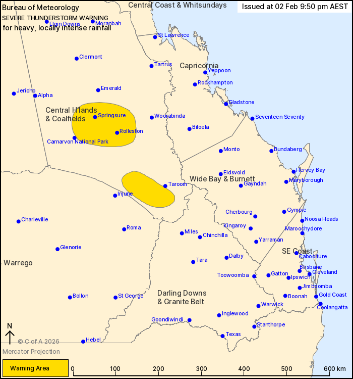
For people in parts of Central Highlands and Coalfields Forecast
District.
Issued at 9:50 pm Monday, 2 February 2026.
Heavy to LOCALLY INTENSE rainfall with thunderstorms this
evening.
Weather Situation: A strong southeasterly surge continues to
trigger thunderstorms in the southeast this evening, with the risk
of heavy to locally intense rainfall.
VERY DANGEROUS THUNDERSTORMS are likely to produce heavy, locally
intense rainfall that may lead to dangerous and life-threatening
flash flooding in the warning area over the next several hours.
Locations which may be affected include Rolleston and
Springsure.
Severe thunderstorms are no longer occurring in the Capricornia
district and the warning for this district is CANCELLED.
80MM OF RAINFALL WAS RECORDED AT EUROMBAH CREEK IN THE 60MIN TO
9:21
PM.
86MM OF RAINFALL WAS RECORDED AT BASALT CREEK IN THE 60MIN TO
8:48
PM.
52 mm of rainfall was recorded at Turkey Mountain (northeast of
Chinchilla) in the 30 minutes to 7:27 pm
39 mm of rainfall was recorded at Mt Playfair (Carnarvon NP) in
the 30 minutes to 4:24 pm.
43 mm of rainfall was recorded on the O'Connor (west of
Millmerran) in the 30 minutes 3.05 pm.
Emergency services advise people to:
* If you have children make sure they are with you or an adult you
trust.
* Park your car undercover away from trees.
* Close doors and windows.
* Keep asthma medications close by. Storms and wind can trigger
asthma attacks.
* Charge mobile phones and power banks in case the power goes
out.
* Put your pets somewhere safe and make sure they can be
identified in case they get lost.
* Do not drive now unless you have to because conditions are
dangerous.
* Tell friends, family and neighbours in the area.
* Go inside a strong building now. Stay inside until the storm has
passed.
02/Feb/2026 11:57 AM


