
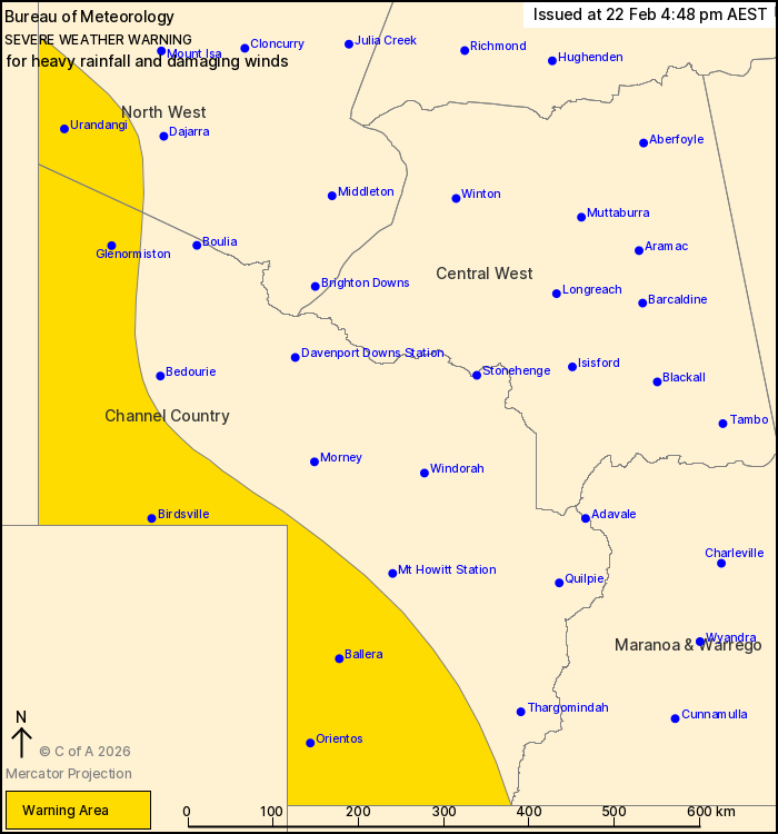
Source: Bureau of Meteorology
For people in parts of North West and Channel Country Forecast
Districts.
Issued at 4:48 pm Sunday, 22 February 2026.
Heavy rainfall and possible damaging wind gusts over far western
Queensland this evening and into Monday.
Weather Situation: A tropical low is located over the southeastern
Northern Territory. Rich tropical moisture surrounding this system
brings the risk of heavy rainfall this evening and into
Monday.
HEAVY RAINFALL which may lead to FLASH FLOODING is forecast for
parts of the North West and Channel Country. Six-hourly rainfall
totals between 50 and 80 mm are possible. 24-hourly rainfall totals
between 60 and 80 mm are likely, with localised falls of 110 mm
possible.
DAMAGING WIND GUSTS of about 90 km/h are possible with showers and
thunderstorms.
Severe weather is likely to contract to only affect far
southwestern Queensland by Monday afternoon, but there remains some
uncertainty around the position and strength of the system. The low
may linger and affect the western Channel Country for most of the
week.
These conditions also threaten cattle and other livestock.
Separate Flood Watches and/or Warnings are current at the time of
issue. Please refer to
https://www.bom.gov.au/weather-and-climate/warnings-and-alerts/ for
more information.
Locations which may be affected include Birdsville, Urandangi,
Ballera, Orientos, Glenormiston and Bulloo Downs.
Emergency services advise people to:
* Park your car undercover away from trees.
* Close doors and windows.
* Keep asthma medications close by. Storms and wind can trigger
asthma attacks.
* Charge mobile phones and power banks in case the power goes
out.
* Put your pets somewhere safe and make sure they can be
identified in case they get lost.
* Do not drive now unless you have to because conditions are
dangerous.
* Tell friends, family and neighbours in the area.
22/Feb/2026 09:55 AM

