
Source: Bureau of Meteorology
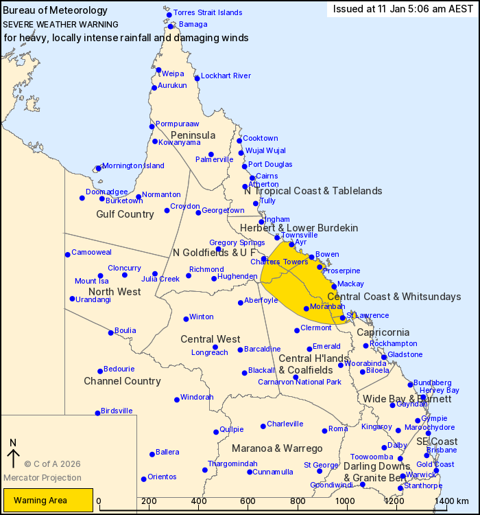
For people in Central Coast and Whitsundays and parts of Northern
Goldfields and Upper Flinders, Herbert and Lower Burdekin, Central
Highlands and Coalfields and Capricornia Forecast Districts.
Issued at 5:06 am Sunday, 11 January 2026.
TROPICAL CYCLONE KOJI IS APPROACHING THE NORTHEAST TROPICAL COAST,
BRINGING HEAVY TO LOCALLY INTENSE RAINFALL AND DAMAGING WINDS
TODAY.
Weather Situation: Tropical Cyclone Koji (12U) is currently a
Category 1 tropical cyclone and is continuing to move south towards
the northeast Queensland coast. Koji is forecast to cross the coast
as a Category 1 tropical cyclone later this morning south of
Ayr.
For COASTAL AREAS: DAMAGING WINDS averaging 55 to 65 km/h with
wind gusts around 100 km/h are expected to continue about exposed
coastal parts between Townsville and Mackay this morning.
HEAVY RAINFALL which may lead to FLASH FLOODING is developing
along coastal parts between Townsville and St Lawrence this
morning. Six-hourly rainfall totals between 80 to 150 mm are
likely. 24-hourly totals between 150 to 250 mm are likely, with
isolated falls in excess of 340 mm possible. Further inland, HEAVY
RAINFALL which may lead to FLASH FLOODING is forecast to develop
later this morning, with six-hourly rainfall totals between 70 and
150 mm possible.
Locally INTENSE RAINFALL which may lead to DANGEROUS AND
LIFE-THREATENING FLASH FLOODING is possible about coastal areas
between Townsville and Proserpine this morning before extending to
Mackay later today, with isolated six-hourly falls in excess of 230
mm possible.
Conditions to persist today over southern parts of the Herbert and
Lower Burdekin and Central Coast and Whitsundays, before possibly
easing during Monday.
A Tropical Cyclone Warning has been issued. Please refer to
Tropical Cyclone warnings and forecast track maps at
https://www.bom.gov.au/weather-and-climate/specialised-forecasts-and-observations/tropical-cyclone.
A separate Severe Weather Warning associated with monsoonal winds
is current for people in the Peninsula. Flood Watch and Warning
products are also current for large parts of Queensland, including
the northeast. A Severe Thunderstorm Warning will be issued if
intense rainfall is detected.
Underlying wet soils will make trees easier to fall about the
northeast tropical coast. Landslips could also occur about steep
and hilly terrain.
For all other current warnings and watches please refer to
https://www.bom.gov.au/weather-and-climate/warnings-and-alerts
Locations which may be affected include Ayr, Bowen, Airlie Beach,
the Whitsunday Islands, Proserpine, Mackay, Moranbah, Sarina,
Carmila, and St Lawrence.
104 km/h wind gust was recorded at Hamilton Island at 4:03
am.
Emergency services advise people to:
* If you have children make sure they are with you or an adult you
trust.
* Park your car undercover away from trees.
* Close doors and windows.
* Keep asthma medications close by. Storms and wind can trigger
asthma attacks.
* Charge mobile phones and power banks in case the power goes
out.
* Put your pets somewhere safe and make sure they can be
identified in case they get lost.
* Do not drive now unless you have to because conditions are
dangerous.
* Tell friends, family and neighbours in the area.
* Go inside a strong building now. Stay inside until the storm has
passed.
10/Jan/2026 07:29 PM


