
Source: Bureau of Meteorology
For people in parts of Northern Goldfields and Upper Flinders,
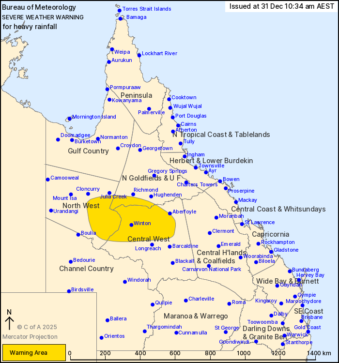
North West and Central West Forecast Districts.
Issued at 10:34 am Wednesday, 31 December 2025.
Heavy rainfall remains possible in northwestern and central
western Queensland today and tomorrow.
Weather Situation: A broad slow-moving low pressure system is
situated near Cloncurry in the northwest of the state and is
expected to remain in place over the coming days. Widespread
moderate rainfall is forecast across inland parts to the southeast
of the low, with a renewed risk of isolated heavy rainfall possible
from later today.
HEAVY RAINFALL which may lead to FLASH FLOODING is forecast to
continue today and possibly into Thursday for parts of the Northern
Goldfields and Upper Flinders, North West and Central West forecast
districts. Widespread six-hourly rainfall totals between 20 to 50
mm are likely, with isolated heavy falls of 80 mm possible.
These conditions also present a risk to cattle and other
livestock.
A separate Severe Weather Warning is current for the northeast
tropical coast. Flood Watches and Flood Warnings are current for
northern Queensland. Please refer to
https://www.bom.gov.au/weather-and-climate/warnings-and-alerts for
more information.
Locations which may be affected include Winton, Evesham Station,
Stamford, Aramac, Muttaburra, Selwyn, Mckinlay, Kynuna and
Corfield.
Emergency services advise people to:
* Park your car undercover away from trees.
* Close doors and windows.
* Keep asthma medications close by. Storms and wind can trigger
asthma attacks.
* Charge mobile phones and power banks in case the power goes
out.
* Put your pets somewhere safe and make sure they can be
identified in case they get lost.
* Do not drive now unless you have to because conditions are
dangerous.
* Tell friends, family and neighbours in the area.
* Go inside a strong building now. Stay inside until the storm has
passed.
31/Dec/2025 12:39 AM

