
Source: Bureau of Meteorology
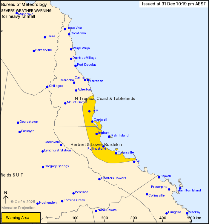
For people in parts of North Tropical Coast and Tablelands and
Herbert and Lower Burdekin Forecast Districts.
Issued at 10:19 pm Wednesday, 31 December 2025.
Heavy rainfall is possible about the northeast coast tonight and
into Thursday.
Weather Situation: A coastal trough over the northeast coast is
combining with a very humid airmass to bring a risk of heavy
rainfall.
HEAVY RAINFALL which may lead to FLASH FLOODING is forecast about
the coast and adjacent inland areas from about Innisfail to Alva
Beach. Six-hourly rainfall totals between 100 to 180 mm are likely,
with isolated falls in excess of 250 mm possible.
A separate Severe Thunderstorm Warning will be issued if very
dangerous thunderstorms with intense rainfall are detected.
A separate Severe Weather Warning is current for northwestern
Queensland. Flood Watches and Flood Warnings are current for
Northern Queensland. Please refer to
https://www.bom.gov.au/weather-and-climate/warnings-and-alerts for
more information.
Locations which may be affected include Townsville, Palm Island,
Ingham, Cardwell, Tully, Rollingstone, Innisfail, Giru, Lucinda and
Abergowrie.
Emergency services advise people to:
* Park your car undercover away from trees.
* Close doors and windows.
* Keep asthma medications close by. Storms and wind can trigger
asthma attacks.
* Charge mobile phones and power banks in case the power goes
out.
* Put your pets somewhere safe and make sure they can be
identified in case they get lost.
* Do not drive now unless you have to because conditions are
dangerous.
* Tell friends, family and neighbours in the area.
* Go inside a strong building now. Stay inside until the storm has
passed.
31/Dec/2025 12:24 PM

