
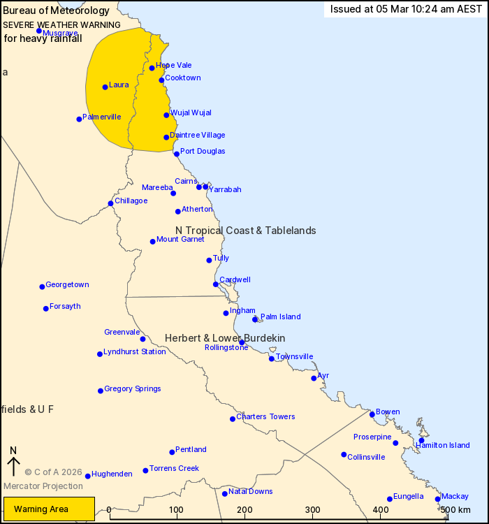
Source: Bureau of Meteorology
For people in parts of Peninsula and North Tropical Coast and
Tablelands Forecast Districts.
Issued at 10:24 am Thursday, 5 March 2026.
Heavy rainfall developing today associated with a tropical low and
the monsoon trough.
Weather Situation:
Tropical Low 29U is offshore, with heavy showers and thunderstorms
extending along the monsoon trough through the Daintree coast. The
low will move onshore tomorrow morning south of Ingham, but the
heaviest rainfall is forecast to be further north of the system
centre.
HEAVY RAINFALL which may lead to FLASH FLOODING is forecast from
this morning between Mossman and just north of Cape Flattery.
Six-hourly rainfall totals between 80 and 160 mm are likely.
24-hourly rainfall totals of 350 mm are possible.
Rainfall is expected to extend inland later on Friday as the low
moves onshore. The location of any areas of heavy rain beyond
Friday remains highly uncertain.
Various Flood Watches and Flood Warnings are current throughout
Queensland, including for the North Tropical Coast and Cape York
Peninsula districts. Please see
https://www.bom.gov.au/weather-and-climate/warnings-and-alerts for
more information.
Locations which may be affected include Hope Vale, Wujal Wujal,
Cooktown, Daintree Village and Laura.
Emergency services advise people to:
* Park your car undercover away from trees.
* Close doors and windows.
* Keep asthma medications close by. Storms and wind can trigger
asthma attacks.
* Charge mobile phones and power banks in case the power goes
out.
* Put your pets somewhere safe and make sure they can be
identified in case they get lost.
* Do not drive now unless you have to because conditions are
dangerous.
* Tell friends, family and neighbours in the area.
* Go inside a strong building now. Stay inside until the storm has
passed.
05/Mar/2026 12:34 AM

