
Source: Bureau of Meteorology
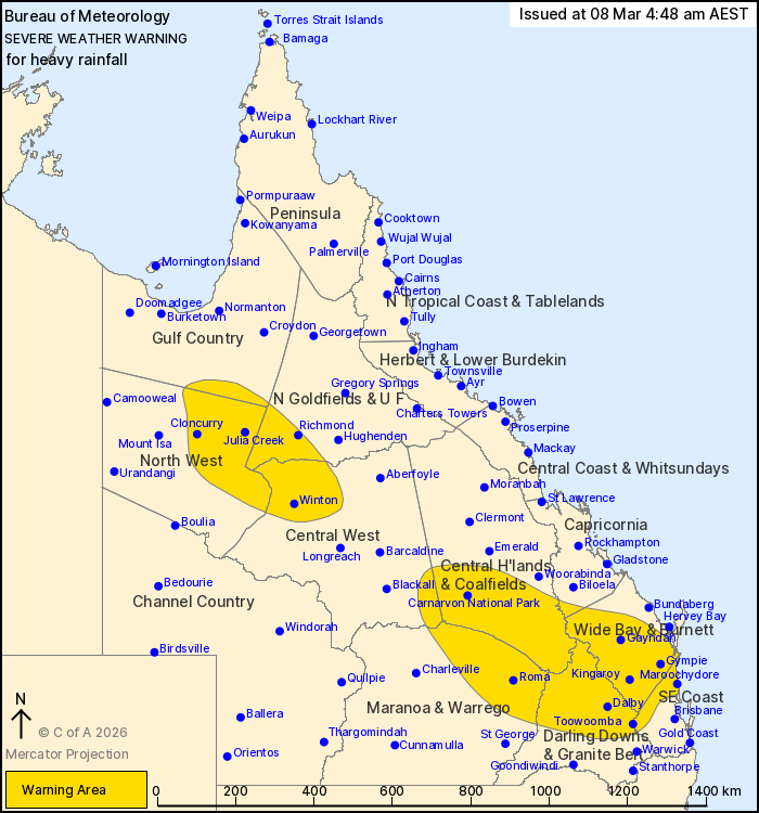
For people in Wide Bay and Burnett and parts of Gulf Country,
Northern Goldfields and Upper Flinders, North West, Central
Highlands and Coalfields, Central West, Capricornia, Maranoa and
Warrego, Darling Downs and Granite Belt and Southeast Coast
Forecast Districts.
Issued at 4:48 am Sunday, 8 March 2026.
Heavy rainfall continuing in the north and southeast.
Weather Situation: Tropical Low 29U is situated in northern parts
of the North West district and will gradually move to the southeast
during Sunday. The monsoon trough extends inland from this low and
is focusing heavy rainfall through the northern interior. Meanwhile
rich tropical moisture feeding into a developing trough in
southeast Queensland will see rainfall increasing during Sunday and
continuing during Monday.
FOR THE NORTHERN INTERIOR: HEAVY RAINFALL which may lead to FLASH
FLOODING is possible over parts of the northern interior this
morning. Six-hourly rainfall totals between 25 and 50 mm are
likely, with isolated totals around 100 mm possible. 24-hourly
rainfall totals between 50 and 70 mm are likely, with isolated
totals around 120 mm possible.
FOR THE SOUTH EAST: HEAVY RAINFALL which may lead to FLASH
FLOODING is expected over parts of the Maranoa and Warrego, Darling
Downs and Granite Belt, Southeast Coast, Wide Bay and Burnett and
Central Highlands and Coalfields. Six-hourly rainfall totals
between 40 and 80 mm are likely, with isolated totals around 100 mm
possible. Isolated falls around 170 mm are possible on the Sunshine
Coast. 24-hourly rainfall totals between 50 and 100 mm are likely,
with isolated totals around 150 mm possible.
There is some uncertainty where the heaviest rainfall will occur,
particularly through the southeast of the state. Further extensions
towards the coast and north into the Capricornia district are
possible for Sunday night into Monday.
Various Flood Watches and Flood Warnings are current throughout
Queensland. Separate Severe Thunderstorm Warnings may be current.
Please see
https://www.bom.gov.au/weather-and-climate/warnings-and-alerts for
more information.
Locations which may be affected include Toowoomba, Dalby,
Maroochydore, Roma, Gympie, Winton, Cloncurry and Kingaroy.
111 mm was recorded at Sardine Creek in the 6 hours to 2:44
am.
Emergency services advise people to:
* Park your car undercover away from trees.
* Close doors and windows.
* Keep asthma medications close by. Storms and wind can trigger
asthma attacks.
* Charge mobile phones and power banks in case the power goes
out.
* Put your pets somewhere safe and make sure they can be
identified in case they get lost.
* Do not drive now unless you have to because conditions are
dangerous.
* Tell friends, family and neighbours in the area.
* Go inside a strong building now. Stay inside until the storm has
passed.
07/Mar/2026 07:23 PM

