
Source: Bureau of Meteorology
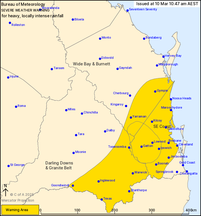
For people in Southeast Coast and parts of Wide Bay and Burnett
and Darling Downs and Granite Belt Forecast Districts.
Issued at 10:47 am Monday, 10 March 2025.
HEAVY TO LOCALLY INTENSE RAINFALL GRADUALLY EASING OVER SOUTHEAST
QUEENSLAND TODAY.
Weather Situation: Ex-Tropical Cyclone Alfred made landfall over
the mainland on Saturday evening and has weakened into a trough
since crossing the coast. The system is still bringing heavy to
locally intense rainfall, which will gradually ease today.
HEAVY RAINFALL which may lead to FLASH FLOODING continues across
parts of southeast Queensland today, including Brisbane, Ipswich
and the Sunshine Coast. Six-hourly rainfall totals between 60 and
100 mm are likely throughout today. 24-hourly totals up to 150 mm
are likely. Heavy rainfall is forecast to ease over southeast
Queensland during the late afternoon and evening.
Locally INTENSE RAINFALL which may lead to DANGEROUS AND
LIFE-THREATENING FLASH FLOODING remains possible in bands of
showers and thunderstorms within the sub-contour over inland parts
of southeast QLD, including Ipswich, Gatton and the Lockyer Valley.
The risk of intense rainfall is forecast to ease during the
afternoon. Six-hourly rainfall totals between 120 and 150 mm are
possible.
If intense rainfall is detected, a separate Detailed Severe
Thunderstorm Warning will be issued.
A separate Severe Thunderstorm Warning may also be current for
regions of the state outside this Severe Weather Warning.
A Flood Watch and Flood Warnings are current for southern and
southeastern Queensland.
For these products, see
http://www.bom.gov.au/australia/warnings/
Locations which may be affected include Warwick, Toowoomba,
Brisbane, Maroochydore, Gympie, Goondiwindi, Stanthorpe, Caboolture
and Ipswich.
As of 11:00 am, numerous significant rainfall observations have
been recorded across southeast Queensland overnight:
207 MM WAS RECORDED AT KINGSHOLME IN THE 6 HOURS TO 9:56 PM.
178 mm was recorded at Wongawallan in the 6 hours to 10:41
pm.
173 mm was recorded at Hotham Creek in the 6 hours to 9:37
pm.
154 mm was recorded at Oxenford Weir in the 6 hours to 10:40
pm.
141 mm WAS RECORDED AT BAROON BOAT RAMP ALERT IN THE 3 HOURS TO
3:37 AM.
112 mm was recorded at Maleny Alert in the 3 hours to 3:46
am.
98 mm was recorded at Rosalie (Baroona Rd) in the 3 hours to 11:43
pm.
Emergency services advise people to:
* If you have children make sure they are with you or an adult you
trust.
* Park your car undercover away from trees.
* Close doors and windows.
* Keep asthma medications close by. Storms and wind can trigger
asthma attacks.
* Charge mobile phones and power banks in case the power goes
out.
* Put your pets somewhere safe and make sure they can be
identified in case they get lost.
* Do not drive now unless you have to because conditions are
dangerous.
* Tell friends, family and neighbours in the area.
* Go inside a strong building now. Stay inside until the storm has
passed.
10/Mar/2025 01:02 AM


