
Source: Bureau of Meteorology
TROPICAL CYCLONE ADVICE NUMBER 5
Issued at 11:04 am EST on Wednesday 18 March 2026
Headline:
Tropical Cyclone Narelle continues to intensify in the northern
Coral Sea, and is expected to bring severe impacts to Far North
Queensland.
Areas Affected:
Warning Zone
None.
Watch Zone
Central Peninsula and Northern Tropical Coast, including Port
Douglas, Lockhart River, and Weipa.
Cancelled Zone
None.
Details of Tropical Cyclone Narelle 34U at 10:00 am AEST:
Intensity: Category 2, sustained winds near the centre of 110
kilometres per hour with wind gusts to 155 kilometres per
hour.
Location: within 45 kilometres of 12.1 degrees South 153.5 degrees
East, estimated to be 600 kilometres northeast of Willis Island and
970 kilometres east northeast of Cooktown.
Movement: west at 17 kilometres per hour.
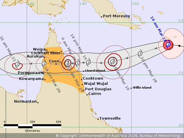
Tropical Cyclone Narelle (34U) is currently at category 2
intensity in the northern Coral Sea. Narelle is expected to move
steadily to the west and approach the far northeast Queensland
coast between Lockhart River and Port Douglas. A severe impact is
likely late on Thursday or on Friday.
After crossing the northeast Queensland coast, most likely on
Friday morning, Narelle is forecast to continue its westward path,
moving across the Cape York Peninsula and into the Gulf of
Carpentaria. As is crosses the Cape York Peninsula Narelle is
likely to weaken, however, it is expected to remain a tropical
cyclone.
Hazards:
VERY DESTRUCTIVE WIND GUSTS in excess of 250 km/h are possible
near the centre of Tropical Cyclone Narelle as it crosses the
coast.
DESTRUCTIVE WIND GUSTS to 155 km/hr are possible from south of
Lockhart River to Cooktown from Thursday night.
Gales with DAMAGING WIND GUSTS to 120 km/hr are possible between
Lockhart River and Port Douglas from Thursday.
Gales with DAMAGING WIND GUSTS to 120 km/hr will also possible
extend across the Cape York Peninsula, including areas between
Weipa and Kowanyama from Thursday afternoon.
HEAVY RAINFALL which may lead to FLASH FLOODING is possible
between Cape Melville and Port Douglas from Thursday evening,
extending inland during Friday. LOCALLY INTENSE RAINFALL is
possible between Lockhart River and Cape Melville, and also inland
areas west of Coen, from Friday.
Tides will be higher than normal between Coen and Port Douglas.
LARGE WAVES may produce MINOR FLOODING of low-lying coastal areas.
There is a small risk that tides may approach the highest tide of
the year during Friday.
Tides in Princess Charlotte Bay may rise significantly above the
normal high tide, DAMAGING WAVES and DANGEROUS FLOODING is possible
for low-lying coastal areas.
Recommended Action:
- Stay informed by checking your local government s Disaster
Dashboards for the latest updates.
- For cyclone preparedness and safety advice, visit the Get Ready
Queensland website www.getready.qld.gov.au
- For non-life threatening emergency assistance contact State
Emergency Services (SES) online via the SES Assistance QLD App,
Apple , Android, online www.132500.qld.gov.au, or call 132 500 from
anywhere in Queensland.
Current
Tropical Cyclones
18/Mar/2026 01:08 AM

