
Source: Bureau of Meteorology
Issued at 10:58 pm EST on Tuesday 17 March 2026
Headline:
Tropical Cyclone Narelle continues to intensify in the northern
Coral Sea, and is expected to bring severe impacts to Far North
Queensland.
Areas Affected:
Warning Zone
None.
Watch Zone
Lockhart River to Port Douglas, and adjacent inland areas.
Cancelled Zone
None.
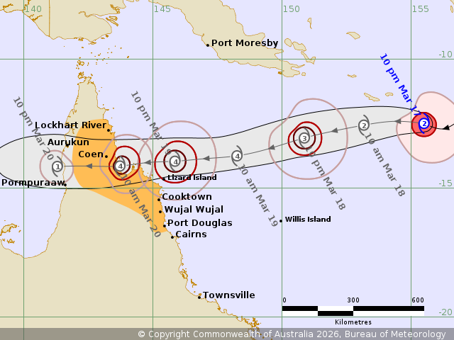
Details of Tropical Cyclone Narelle 34U at 10:00 pm AEST:
Intensity: Category 2, sustained winds near the centre of 100
kilometres per hour with wind gusts to 140 kilometres per
hour.
Location: within 35 kilometres of 12.5 degrees South 155.5 degrees
East, estimated to be 730 kilometres northeast of Willis Island and
1160 kilometres east northeast of Cooktown.
Movement: west at 15 kilometres per hour.
Tropical Cyclone Narelle (34U) has intensified into a category 2
system in the northern Coral Sea. Narelle is expected to move
steadily to the west and approach the far northeast Queensland
coast between Lockhart River and Port Douglas. A severe impact is
likely late in the week.
Hazards:
DESTRUCTIVE WIND GUSTS to 155 km/hr are possible between Coen and
Cooktown from Thursday night.
Gales with DAMAGING WIND GUSTS to 120 km/hr are possible between
Cape Melville and Port Douglas from early Thursday morning.
Gales with DAMAGING WIND GUSTS to 120 km/hr are also possible
between Lockhart River and Cape Melville from Thursday
afternoon.
HEAVY RAINFALL which may lead to FLASH FLOODING is possible
between Cape Melville and Port Douglas from Thursday evening,
extending inland during Friday. LOCALLY INTENSE RAINFALL is
possible between Lockhart River and Cape Melville, and also inland
areas west of Coen, from Friday.
Tides will be higher than normal between Coen and Port Douglas.
LARGE WAVES may produce MINOR FLOODING of low-lying coastal areas.
There is a small risk that tides may approach the highest tide of
the year during Friday.
Tides in Princess Charlotte Bay may rise significantly above the
normal high tide, DAMAGING WAVES and DANGEROUS FLOODING is possible
for low-lying coastal areas.
Recommended Action:
- Stay informed by checking your local government s Disaster
Dashboards for the latest updates.
- For cyclone preparedness and safety advice, visit the Get Ready
Queensland website www.getready.qld.gov.au
- For non-life threatening emergency assistance contact State
Emergency Services (SES) online via the SES Assistance QLD App,
Apple , Android, online www.132500.qld.gov.au, or call 132 500 from
anywhere
Current
Tropical Cyclones
17/Mar/2026 01:12 PM

