
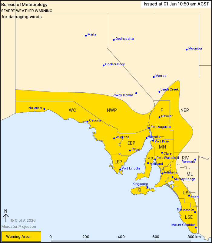
Source: Bureau of Meteorology
For people in Adelaide Metropolitan, Mount Lofty Ranges, West
Coast, Lower Eyre Peninsula, Eastern Eyre Peninsula, Yorke
Peninsula, Flinders, Mid North, Kangaroo Island, Upper South East,
Lower South East and parts of Riverland, Murraylands, North West
Pastoral and North East Pastoral districts.
Issued at 10:50 am Monday, 1 June 2026.
Damaging winds to affect South Australia today and into Tuesday
morning.
Weather Situation: A strong cold front will sweep across the state
today bringing isolated damaging wind gusts to much of the state. A
deep low pressure system will follow this afternoon bringing a
broader damaging wind risk over western parts of the state,
extending eastwards to the Adelaide region as well as central and
southeastern parts during Monday evening as the low passes to the
south of Adelaide overnight.
DAMAGING WINDS averaging 60 to 70 km/h with gusts to 100 km/h are
likely about the West Coast, Eyre Peninsula and Yorke Peninsula
today, extending to the remainder of the warning area, including
Adelaide, during Monday evening.
DAMAGING WINDS are expected to ease over coastal and low lying
areas, including Adelaide, from early Tuesday morning, and then
gradually ease over the Flinders Ranges and Mt Lofty Ranges during
Tuesday afternoon and evening.
A separate warning for ABNORMALLY HIGH TIDES is also current for
parts of the coast. For more details, refer to
https://www.bom.gov.au/weather-and-climate/warnings-and-alerts
Locations which may be affected include Adelaide, Port Lincoln,
Strathalbyn, Maitland, Whyalla, Mount Gambier, Ceduna and Port
Augusta.
94 km/h wind gust was recorded at Cleve at 7:07 am.
Sustained 68 km/h winds were recorded at Warburto Point (near
Moonta) around 8:15 am.
The State Emergency Service advises that people should:
* Move vehicles under cover or away from trees;
* Secure or put away loose items around your property.
* Stay indoors, away from windows, while conditions are
severe.
01/Jun/2026 01:47 AM

