
Source: Bureau of Meteorology
For people in parts of Wide Bay and Burnett and Southeast Coast
Forecast Districts.
Issued at 8:19 pm Friday, 15 December 2023.
VERY DANGEROUS STORMS WITH DESTRUCTIVE WINDS AND INTENSE
RAINFALL
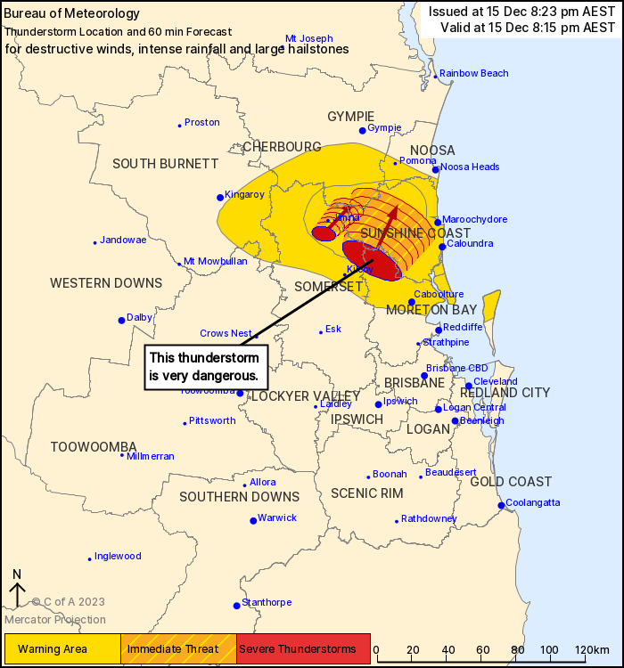
Weather Situation: Severe thunderstorms are ongoing in the
southeast this evening, and are moving slowly towards the
northeast.
Severe thunderstorms are likely to produce damaging, LOCALLY
DESTRUCTIVE WINDS, heavy, LOCALLY INTENSE RAINFALL that may lead to
dangerous and life-threatening flash flooding and large hailstones
over the next several hours in parts of the Wide Bay and Burnett
and Southeast Coast districts. Locations which may be affected
include Nambour.
Severe thunderstorms are likely to produce damaging winds, large
hailstones and heavy rainfall that may lead to flash flooding over
the next several hours in parts of the Wide Bay and Burnett and
Southeast Coast districts. Locations which may be affected include
Maroochydore, Caboolture, Moreton Island, Kilcoy, Nambour and
Nanango.
Various sites between Woodford and Caboolture recorded 60 to 90 mm
of rainfall in 30 minutes
Archerfield Airport recorded a 169 km/h wind gust at 4:31pm.
3 to 4 cm hail in various suburbs south of Brisbane River between
4:00 and 5:00 pm
Round Mountain recorded 53.0mm in 30 minutes to 3:08pm
Emergency services advise people to:
* If you have children make sure they are with you or an adult you
trust.
* Pack away, secure or tie down outdoor furniture, toys and
trampolines if it s safe to do so.
* Park your car undercover away from trees.
* Close doors and windows.
* Keep asthma medications close by. Storms and wind can trigger
asthma attacks.
* Charge mobile phones and power banks in case the power goes
out.
* Put your pets somewhere safe and make sure they can be
identified in case they get lost.
* Do not drive now unless you have to because conditions are
dangerous.
* Tell friends, family and neighbours in the area.
* Go inside a strong building now. Stay inside until the storm has
passed.
15/Dec/2023 10:34 AM

